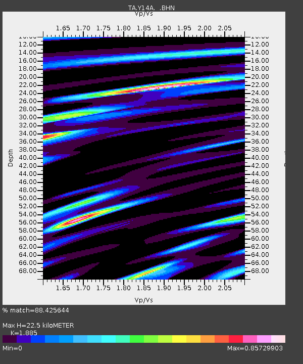
Y14A Wickenburg, AZ, USA - Earthquake Result Viewer

Earthquake location: Rat Islands, Aleutian Islands
Earthquake latitude/longitude: 52.2/176.2
Earthquake time(UTC): 2006/06/27 (178) 02:39:35 GMT
Earthquake Depth: 34 km
Earthquake Magnitude: 5.6 MB, 6.0 MS, 6.2 MW, 6.2 MW
Earthquake Catalog/Contributor: WHDF/NEIC
Network: TA USArray Transportable Network (new EarthScope stations)
Station: Y14A Wickenburg, AZ, USA
Lat/Lon: 33.94 N/113.00 W
Elevation: 731 m
Distance: 52.7 deg
Az: 80.839 deg
Baz: 313.047 deg
Ray Param: 0.066538535
Estimated Moho Depth: 22.5 km
Estimated Crust Vp/Vs: 1.88
Assumed Crust Vp: 6.264 km/s
Estimated Crust Vs: 3.323 km/s
Estimated Crust Poisson's Ratio: 0.30
Radial Match: 88.425644 %
Radial Bump: 400
Transverse Match: 67.17923 %
Transverse Bump: 400
SOD ConfigId: 2665
Insert Time: 2010-03-07 05:16:43.913 +0000
GWidth: 2.5
Max Bumps: 400
Tol: 0.001

Signal To Noise

ChannelStoNSTALTA
TA:Y14A: :BHN:20060627T02:48:15.775005Z2.26001649.7901726E-84.3319034E-8
TA:Y14A: :BHE:20060627T02:48:15.775005Z4.97734741.5879272E-73.190308E-8
TA:Y14A: :BHZ:20060627T02:48:15.775005Z4.80370573.539546E-77.368365E-8
Arrivals
Ps3.3 SECOND
PpPs9.9 SECOND
PsPs/PpSs13 SECOND