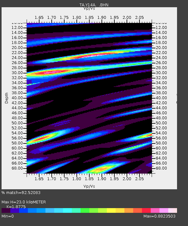
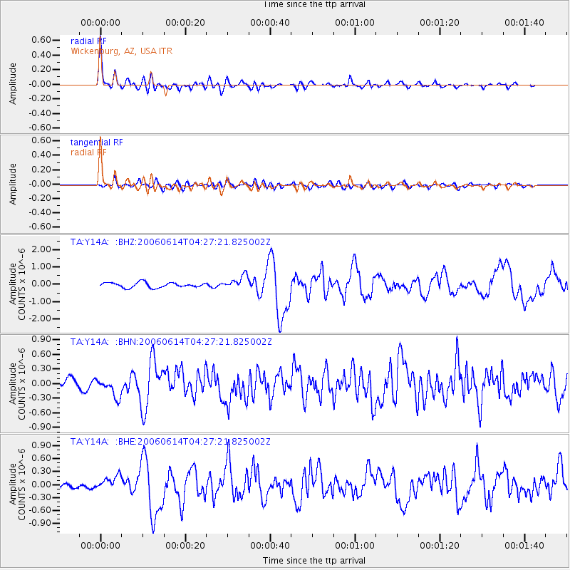
Y14A Wickenburg, AZ, USA - Earthquake Result Viewer

Earthquake location: Rat Islands, Aleutian Islands
Earthquake latitude/longitude: 51.8/177.1
Earthquake time(UTC): 2006/06/14 (165) 04:18:42 GMT
Earthquake Depth: 14 km
Earthquake Magnitude: 5.9 MB, 6.4 MS, 6.4 MW, 6.4 MW
Earthquake Catalog/Contributor: WHDF/NEIC
Network: TA USArray Transportable Network (new EarthScope stations)
Station: Y14A Wickenburg, AZ, USA
Lat/Lon: 33.94 N/113.00 W
Elevation: 731 m
Distance: 52.2 deg
Az: 81.134 deg
Baz: 312.372 deg
Ray Param: 0.06689675
Estimated Moho Depth: 23.0 km
Estimated Crust Vp/Vs: 1.88
Assumed Crust Vp: 6.264 km/s
Estimated Crust Vs: 3.336 km/s
Estimated Crust Poisson's Ratio: 0.30
Radial Match: 92.52083 %
Radial Bump: 400
Transverse Match: 74.35207 %
Transverse Bump: 400
SOD ConfigId: 5745
Insert Time: 2010-03-07 05:16:49.992 +0000
GWidth: 2.5
Max Bumps: 400
Tol: 0.001

Signal To Noise

ChannelStoNSTALTA
TA:Y14A: :BHN:20060614T04:27:21.825002Z2.65530471.9738064E-77.4334466E-8
TA:Y14A: :BHE:20060614T04:27:21.825002Z1.48687221.678474E-71.1288623E-7
TA:Y14A: :BHZ:20060614T04:27:21.825002Z2.68552113.9321264E-71.464195E-7
Arrivals
Ps3.4 SECOND
PpPs10 SECOND
PsPs/PpSs13 SECOND