You are here: Home > Network List > TA - USArray Transportable Network (new EarthScope stations) Stations List
> Station Y14A Wickenburg, AZ, USA > Earthquake Result Viewer
Y14A Wickenburg, AZ, USA - Earthquake Result Viewer
| Earthquake location: |
Panama-Costa Rica Border Region |
| Earthquake latitude/longitude: |
8.2/-82.9 |
| Earthquake time(UTC): |
2006/05/01 (121) 07:47:59 GMT |
| Earthquake Depth: |
13 km |
| Earthquake Magnitude: |
5.1 MB, 5.6 MS, 5.9 MW, 5.9 MW |
| Earthquake Catalog/Contributor: |
WHDF/NEIC |
|
| Network: |
TA USArray Transportable Network (new EarthScope stations) |
| Station: |
Y14A Wickenburg, AZ, USA |
| Lat/Lon: |
33.94 N/113.00 W |
| Elevation: |
731 m |
|
| Distance: |
37.8 deg |
| Az: |
317.082 deg |
| Baz: |
125.818 deg |
| Ray Param: |
0.075931974 |
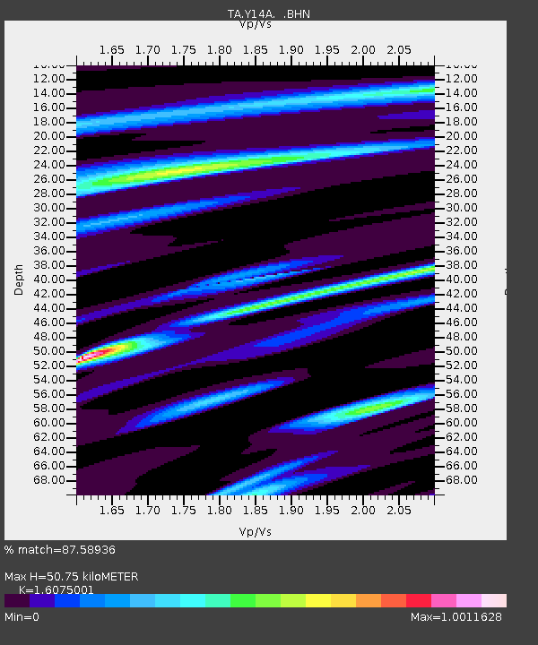
| Estimated Moho Depth: |
50.75 km |
| Estimated Crust Vp/Vs: |
1.61 |
| Assumed Crust Vp: |
6.264 km/s |
| Estimated Crust Vs: |
3.897 km/s |
| Estimated Crust Poisson's Ratio: |
0.18 |
|
| Radial Match: |
87.58936 % |
| Radial Bump: |
357 |
| Transverse Match: |
70.4391 % |
| Transverse Bump: |
400 |
| SOD ConfigId: |
2669 |
| Insert Time: |
2010-03-07 05:16:55.579 +0000 |
| GWidth: |
2.5 |
| Max Bumps: |
400 |
| Tol: |
0.001 |
|

Signal To Noise
| Channel | StoN | STA | LTA |
| TA:Y14A: :BHN:20060501T07:54:44.849015Z | 3.943217 | 3.5582644E-7 | 9.02376E-8 |
| TA:Y14A: :BHE:20060501T07:54:44.849015Z | 2.857043 | 4.3337045E-7 | 1.5168496E-7 |
| TA:Y14A: :BHZ:20060501T07:54:44.849015Z | 6.6342278 | 8.7033607E-7 | 1.3118874E-7 |
| Arrivals |
| Ps | 5.3 SECOND |
| PpPs | 20 SECOND |
| PsPs/PpSs | 25 SECOND |


