You are here: Home > Network List > US - United States National Seismic Network Stations List
> Station NEW Newport, Washington, USA > Earthquake Result Viewer
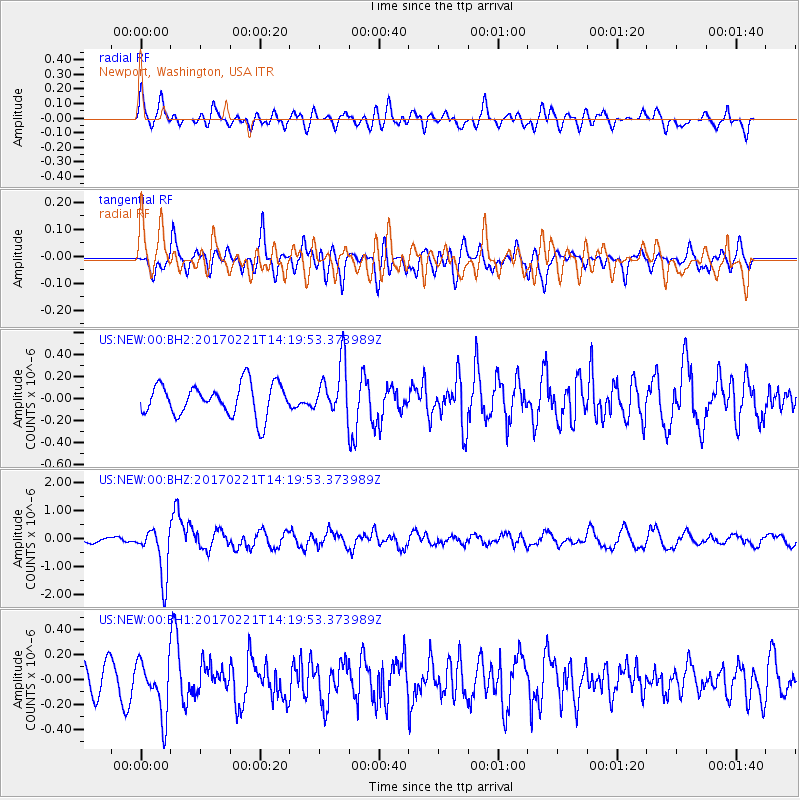
NEW Newport, Washington, USA - Earthquake Result Viewer
*The percent match for this event was below the threshold and hence no stack was calculated.
| Earthquake location: |
Southern Bolivia |
| Earthquake latitude/longitude: |
-19.3/-63.9 |
| Earthquake time(UTC): |
2017/02/21 (052) 14:09:04 GMT |
| Earthquake Depth: |
598 km |
| Earthquake Magnitude: |
6.5 Mww |
| Earthquake Catalog/Contributor: |
NEIC PDE/us |
|
| Network: |
US United States National Seismic Network |
| Station: |
NEW Newport, Washington, USA |
| Lat/Lon: |
48.26 N/117.12 W |
| Elevation: |
760 m |
|
| Distance: |
82.3 deg |
| Az: |
327.314 deg |
| Baz: |
130.234 deg |
| Ray Param: |
$rayparam |
*The percent match for this event was below the threshold and hence was not used in the summary stack. |
|
| Radial Match: |
53.23603 % |
| Radial Bump: |
400 |
| Transverse Match: |
62.592278 % |
| Transverse Bump: |
400 |
| SOD ConfigId: |
1992691 |
| Insert Time: |
2017-03-07 14:16:38.643 +0000 |
| GWidth: |
2.5 |
| Max Bumps: |
400 |
| Tol: |
0.001 |
|
Signal To Noise
| Channel | StoN | STA | LTA |
| US:NEW:00:BHZ:20170221T14:19:53.373989Z | 7.765077 | 8.882269E-7 | 1.1438739E-7 |
| US:NEW:00:BH1:20170221T14:19:53.373989Z | 2.0505216 | 2.1706359E-7 | 1.0585774E-7 |
| US:NEW:00:BH2:20170221T14:19:53.373989Z | 1.6245493 | 2.3580819E-7 | 1.45153E-7 |
| Arrivals |
| Ps | |
| PpPs | |
| PsPs/PpSs | |


