You are here: Home > Network List > TA - USArray Transportable Network (new EarthScope stations) Stations List
> Station Y14A Wickenburg, AZ, USA > Earthquake Result Viewer
Y14A Wickenburg, AZ, USA - Earthquake Result Viewer
| Earthquake location: |
South Of Mariana Islands |
| Earthquake latitude/longitude: |
12.5/143.2 |
| Earthquake time(UTC): |
2008/05/09 (130) 21:51:29 GMT |
| Earthquake Depth: |
76 km |
| Earthquake Magnitude: |
6.1 MB, 6.7 MW, 6.7 MW |
| Earthquake Catalog/Contributor: |
WHDF/NEIC |
|
| Network: |
TA USArray Transportable Network (new EarthScope stations) |
| Station: |
Y14A Wickenburg, AZ, USA |
| Lat/Lon: |
33.94 N/113.00 W |
| Elevation: |
731 m |
|
| Distance: |
94.3 deg |
| Az: |
54.052 deg |
| Baz: |
288.026 deg |
| Ray Param: |
0.04104165 |
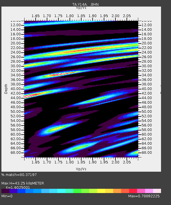
| Estimated Moho Depth: |
43.25 km |
| Estimated Crust Vp/Vs: |
1.60 |
| Assumed Crust Vp: |
6.264 km/s |
| Estimated Crust Vs: |
3.909 km/s |
| Estimated Crust Poisson's Ratio: |
0.18 |
|
| Radial Match: |
80.37197 % |
| Radial Bump: |
400 |
| Transverse Match: |
51.695942 % |
| Transverse Bump: |
400 |
| SOD ConfigId: |
2504 |
| Insert Time: |
2010-03-07 05:17:24.688 +0000 |
| GWidth: |
2.5 |
| Max Bumps: |
400 |
| Tol: |
0.001 |
|

Signal To Noise
| Channel | StoN | STA | LTA |
| TA:Y14A: :BHN:20080509T22:04:09.149006Z | 3.0518777 | 4.7367527E-7 | 1.5520781E-7 |
| TA:Y14A: :BHE:20080509T22:04:09.149006Z | 0.91915184 | 1.1239029E-7 | 1.2227608E-7 |
| TA:Y14A: :BHZ:20080509T22:04:09.149006Z | 1.6134237 | 1.5171595E-7 | 9.403355E-8 |
| Arrivals |
| Ps | 4.2 SECOND |
| PpPs | 18 SECOND |
| PsPs/PpSs | 22 SECOND |


