You are here: Home > Network List > US - United States National Seismic Network Stations List
> Station AMTX Amarillo, Texas, USA > Earthquake Result Viewer
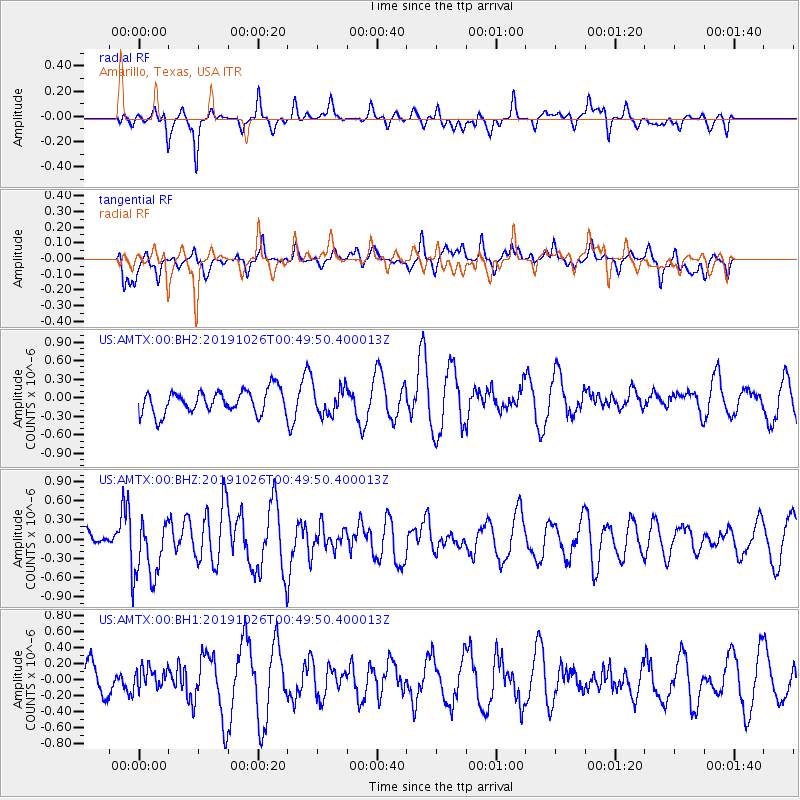
AMTX Amarillo, Texas, USA - Earthquake Result Viewer
*The percent match for this event was below the threshold and hence no stack was calculated.
| Earthquake location: |
Fox Islands, Aleutian Islands |
| Earthquake latitude/longitude: |
52.3/-170.2 |
| Earthquake time(UTC): |
2019/10/26 (299) 00:41:25 GMT |
| Earthquake Depth: |
35 km |
| Earthquake Magnitude: |
5.8 mww |
| Earthquake Catalog/Contributor: |
NEIC PDE/us |
|
| Network: |
US United States National Seismic Network |
| Station: |
AMTX Amarillo, Texas, USA |
| Lat/Lon: |
34.53 N/101.41 W |
| Elevation: |
1010 m |
|
| Distance: |
51.0 deg |
| Az: |
81.848 deg |
| Baz: |
312.641 deg |
| Ray Param: |
$rayparam |
*The percent match for this event was below the threshold and hence was not used in the summary stack. |
|
| Radial Match: |
53.00254 % |
| Radial Bump: |
333 |
| Transverse Match: |
56.46623 % |
| Transverse Bump: |
392 |
| SOD ConfigId: |
19951751 |
| Insert Time: |
2019-11-09 00:56:06.548 +0000 |
| GWidth: |
2.5 |
| Max Bumps: |
400 |
| Tol: |
0.001 |
|
Signal To Noise
| Channel | StoN | STA | LTA |
| US:AMTX:00:BHZ:20191026T00:49:50.400013Z | 2.4806254 | 4.746104E-7 | 1.913269E-7 |
| US:AMTX:00:BH1:20191026T00:49:50.400013Z | 0.6030306 | 1.3722584E-7 | 2.2756032E-7 |
| US:AMTX:00:BH2:20191026T00:49:50.400013Z | 1.296016 | 2.7923465E-7 | 2.1545618E-7 |
| Arrivals |
| Ps | |
| PpPs | |
| PsPs/PpSs | |


