You are here: Home > Network List > TA - USArray Transportable Network (new EarthScope stations) Stations List
> Station Y14A Wickenburg, AZ, USA > Earthquake Result Viewer
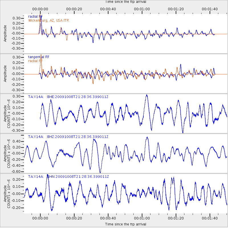
Y14A Wickenburg, AZ, USA - Earthquake Result Viewer
*The percent match for this event was below the threshold and hence no stack was calculated.
| Earthquake location: |
Santa Cruz Islands |
| Earthquake latitude/longitude: |
-12.9/166.3 |
| Earthquake time(UTC): |
2009/10/08 (281) 21:16:13 GMT |
| Earthquake Depth: |
35 km |
| Earthquake Magnitude: |
5.7 MB, 5.9 MS, 5.9 MW |
| Earthquake Catalog/Contributor: |
WHDF/NEIC |
|
| Network: |
TA USArray Transportable Network (new EarthScope stations) |
| Station: |
Y14A Wickenburg, AZ, USA |
| Lat/Lon: |
33.94 N/113.00 W |
| Elevation: |
731 m |
|
| Distance: |
89.5 deg |
| Az: |
55.127 deg |
| Baz: |
254.196 deg |
| Ray Param: |
$rayparam |
*The percent match for this event was below the threshold and hence was not used in the summary stack. |
|
| Radial Match: |
65.04266 % |
| Radial Bump: |
400 |
| Transverse Match: |
52.53598 % |
| Transverse Bump: |
400 |
| SOD ConfigId: |
2622 |
| Insert Time: |
2010-03-07 05:18:19.685 +0000 |
| GWidth: |
2.5 |
| Max Bumps: |
400 |
| Tol: |
0.001 |
|
Signal To Noise
| Channel | StoN | STA | LTA |
| TA:Y14A: :BHZ:20091008T21:28:36.399011Z | 2.1604228 | 2.3439118E-7 | 1.084932E-7 |
| TA:Y14A: :BHN:20091008T21:28:36.399011Z | 2.4355435 | 1.2815535E-7 | 5.2618784E-8 |
| TA:Y14A: :BHE:20091008T21:28:36.399011Z | 0.97166455 | 1.04914605E-7 | 1.07974095E-7 |
| Arrivals |
| Ps | |
| PpPs | |
| PsPs/PpSs | |


