You are here: Home > Network List > MQ - Martinique Seismic and Volcano Observatory Network Stations List
> Station LAM Morne Lacroix - Martinique > Earthquake Result Viewer
LAM Morne Lacroix - Martinique - Earthquake Result Viewer
| Earthquake location: |
Southern Bolivia |
| Earthquake latitude/longitude: |
-19.3/-63.9 |
| Earthquake time(UTC): |
2017/02/21 (052) 14:09:04 GMT |
| Earthquake Depth: |
598 km |
| Earthquake Magnitude: |
6.5 Mww |
| Earthquake Catalog/Contributor: |
NEIC PDE/us |
|
| Network: |
MQ Martinique Seismic and Volcano Observatory Network |
| Station: |
LAM Morne Lacroix - Martinique |
| Lat/Lon: |
14.81 N/61.16 W |
| Elevation: |
1240 m |
|
| Distance: |
34.0 deg |
| Az: |
4.737 deg |
| Baz: |
184.626 deg |
| Ray Param: |
0.07494229 |
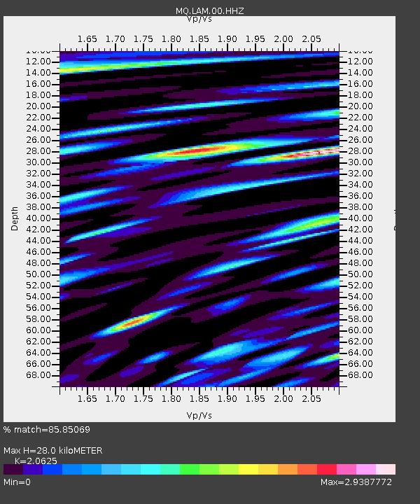
| Estimated Moho Depth: |
28.0 km |
| Estimated Crust Vp/Vs: |
2.06 |
| Assumed Crust Vp: |
5.88 km/s |
| Estimated Crust Vs: |
2.851 km/s |
| Estimated Crust Poisson's Ratio: |
0.35 |
|
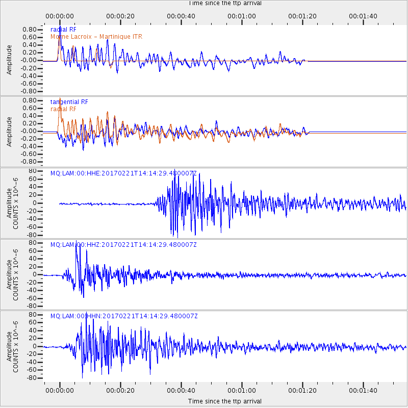
| Radial Match: |
85.85069 % |
| Radial Bump: |
400 |
| Transverse Match: |
61.94086 % |
| Transverse Bump: |
400 |
| SOD ConfigId: |
1992691 |
| Insert Time: |
2017-03-07 14:18:16.473 +0000 |
| GWidth: |
2.5 |
| Max Bumps: |
400 |
| Tol: |
0.001 |
|
Signal To Noise
| Channel | StoN | STA | LTA |
| MQ:LAM:00:HHZ:20170221T14:14:29.480007Z | 25.32937 | 1.09954E-5 | 4.3409685E-7 |
| MQ:LAM:00:HHN:20170221T14:14:29.480007Z | 5.2233005 | 5.6993663E-6 | 1.0911427E-6 |
| MQ:LAM:00:HHE:20170221T14:14:29.480007Z | 9.537354 | 9.0734775E-6 | 9.5136204E-7 |
| Arrivals |
| Ps | 5.3 SECOND |
| PpPs | 14 SECOND |
| PsPs/PpSs | 19 SECOND |


