You are here: Home > Network List > TA - USArray Transportable Network (new EarthScope stations) Stations List
> Station Y14A Wickenburg, AZ, USA > Earthquake Result Viewer
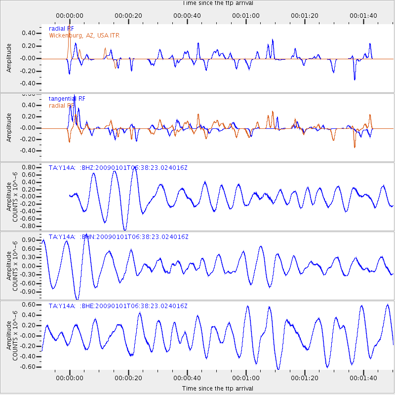
Y14A Wickenburg, AZ, USA - Earthquake Result Viewer
*The percent match for this event was below the threshold and hence no stack was calculated.
| Earthquake location: |
Southern East Pacific Rise |
| Earthquake latitude/longitude: |
-34.8/-107.6 |
| Earthquake time(UTC): |
2009/01/01 (001) 06:27:51 GMT |
| Earthquake Depth: |
10 km |
| Earthquake Magnitude: |
5.8 MW, 5.2 MS, 5.1 MB, 5.8 MW |
| Earthquake Catalog/Contributor: |
WHDF/NEIC |
|
| Network: |
TA USArray Transportable Network (new EarthScope stations) |
| Station: |
Y14A Wickenburg, AZ, USA |
| Lat/Lon: |
33.94 N/113.00 W |
| Elevation: |
731 m |
|
| Distance: |
68.6 deg |
| Az: |
355.217 deg |
| Baz: |
175.268 deg |
| Ray Param: |
$rayparam |
*The percent match for this event was below the threshold and hence was not used in the summary stack. |
|
| Radial Match: |
70.78897 % |
| Radial Bump: |
400 |
| Transverse Match: |
66.00456 % |
| Transverse Bump: |
400 |
| SOD ConfigId: |
2658 |
| Insert Time: |
2010-03-07 05:18:42.663 +0000 |
| GWidth: |
2.5 |
| Max Bumps: |
400 |
| Tol: |
0.001 |
|
Signal To Noise
| Channel | StoN | STA | LTA |
| TA:Y14A: :BHN:20090101T06:38:23.024016Z | 1.6001194 | 7.29201E-7 | 4.5571664E-7 |
| TA:Y14A: :BHE:20090101T06:38:23.024016Z | 0.37026718 | 1.4109465E-7 | 3.810617E-7 |
| TA:Y14A: :BHZ:20090101T06:38:23.024016Z | 0.50215405 | 2.298403E-7 | 4.5770872E-7 |
| Arrivals |
| Ps | |
| PpPs | |
| PsPs/PpSs | |


