You are here: Home > Network List > CI - Caltech Regional Seismic Network Stations List
> Station MPM Manuel Prospect Mine, California, USA > Earthquake Result Viewer
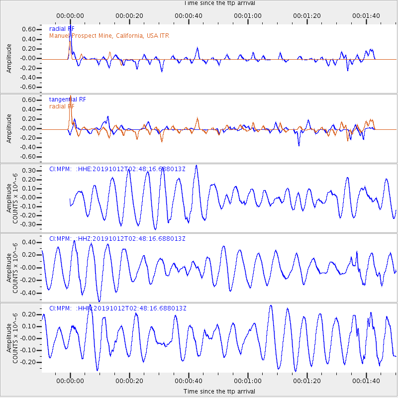
MPM Manuel Prospect Mine, California, USA - Earthquake Result Viewer
*The percent match for this event was below the threshold and hence no stack was calculated.
| Earthquake location: |
New Britain Region, P.N.G. |
| Earthquake latitude/longitude: |
-5.1/152.6 |
| Earthquake time(UTC): |
2019/10/12 (285) 02:35:39 GMT |
| Earthquake Depth: |
44 km |
| Earthquake Magnitude: |
5.6 mb |
| Earthquake Catalog/Contributor: |
NEIC PDE/us |
|
| Network: |
CI Caltech Regional Seismic Network |
| Station: |
MPM Manuel Prospect Mine, California, USA |
| Lat/Lon: |
36.06 N/117.49 W |
| Elevation: |
185 m |
|
| Distance: |
92.9 deg |
| Az: |
54.225 deg |
| Baz: |
265.824 deg |
| Ray Param: |
$rayparam |
*The percent match for this event was below the threshold and hence was not used in the summary stack. |
|
| Radial Match: |
69.7243 % |
| Radial Bump: |
400 |
| Transverse Match: |
60.56928 % |
| Transverse Bump: |
400 |
| SOD ConfigId: |
19951751 |
| Insert Time: |
2019-11-10 01:19:33.287 +0000 |
| GWidth: |
2.5 |
| Max Bumps: |
400 |
| Tol: |
0.001 |
|
Signal To Noise
| Channel | StoN | STA | LTA |
| CI:MPM: :HHZ:20191012T02:48:16.688013Z | 1.3941401 | 2.892817E-7 | 2.0749829E-7 |
| CI:MPM: :HHN:20191012T02:48:16.688013Z | 0.98803973 | 9.1739516E-8 | 9.285003E-8 |
| CI:MPM: :HHE:20191012T02:48:16.688013Z | 1.3723425 | 2.1876309E-7 | 1.5940853E-7 |
| Arrivals |
| Ps | |
| PpPs | |
| PsPs/PpSs | |


