You are here: Home > Network List > TA - USArray Transportable Network (new EarthScope stations) Stations List
> Station E18K Tukpahlearik Creek, AK, USA > Earthquake Result Viewer
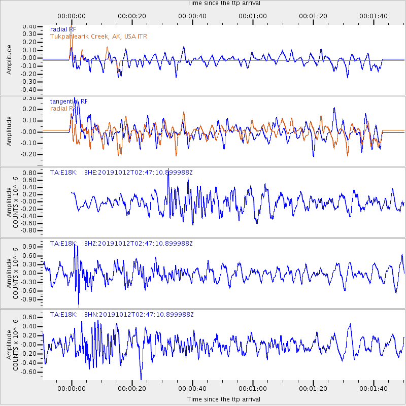
E18K Tukpahlearik Creek, AK, USA - Earthquake Result Viewer
*The percent match for this event was below the threshold and hence no stack was calculated.
| Earthquake location: |
New Britain Region, P.N.G. |
| Earthquake latitude/longitude: |
-5.1/152.6 |
| Earthquake time(UTC): |
2019/10/12 (285) 02:35:39 GMT |
| Earthquake Depth: |
44 km |
| Earthquake Magnitude: |
5.6 mb |
| Earthquake Catalog/Contributor: |
NEIC PDE/us |
|
| Network: |
TA USArray Transportable Network (new EarthScope stations) |
| Station: |
E18K Tukpahlearik Creek, AK, USA |
| Lat/Lon: |
67.42 N/160.60 W |
| Elevation: |
297 m |
|
| Distance: |
79.5 deg |
| Az: |
16.628 deg |
| Baz: |
227.573 deg |
| Ray Param: |
$rayparam |
*The percent match for this event was below the threshold and hence was not used in the summary stack. |
|
| Radial Match: |
46.839336 % |
| Radial Bump: |
400 |
| Transverse Match: |
47.291393 % |
| Transverse Bump: |
400 |
| SOD ConfigId: |
19951751 |
| Insert Time: |
2019-11-10 01:21:37.987 +0000 |
| GWidth: |
2.5 |
| Max Bumps: |
400 |
| Tol: |
0.001 |
|
Signal To Noise
| Channel | StoN | STA | LTA |
| TA:E18K: :BHZ:20191012T02:47:10.899988Z | 2.23889 | 4.2393984E-7 | 1.8935269E-7 |
| TA:E18K: :BHN:20191012T02:47:10.899988Z | 1.1865739 | 2.0709027E-7 | 1.7452791E-7 |
| TA:E18K: :BHE:20191012T02:47:10.899988Z | 2.3821125 | 3.2734803E-7 | 1.3741922E-7 |
| Arrivals |
| Ps | |
| PpPs | |
| PsPs/PpSs | |


