You are here: Home > Network List > TA - USArray Transportable Network (new EarthScope stations) Stations List
> Station L10A Juniper Basin Ranch, Riddle, ID, USA > Earthquake Result Viewer
L10A Juniper Basin Ranch, Riddle, ID, USA - Earthquake Result Viewer
| Earthquake location: |
Southern Peru |
| Earthquake latitude/longitude: |
-16.0/-71.7 |
| Earthquake time(UTC): |
2008/07/08 (190) 09:13:07 GMT |
| Earthquake Depth: |
123 km |
| Earthquake Magnitude: |
5.8 MB, 6.2 MW, 6.2 MW |
| Earthquake Catalog/Contributor: |
WHDF/NEIC |
|
| Network: |
TA USArray Transportable Network (new EarthScope stations) |
| Station: |
L10A Juniper Basin Ranch, Riddle, ID, USA |
| Lat/Lon: |
42.08 N/116.47 W |
| Elevation: |
1537 m |
|
| Distance: |
71.0 deg |
| Az: |
326.348 deg |
| Baz: |
134.28 deg |
| Ray Param: |
0.05432103 |
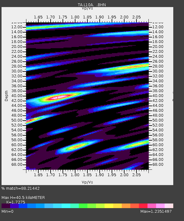
| Estimated Moho Depth: |
40.5 km |
| Estimated Crust Vp/Vs: |
1.73 |
| Assumed Crust Vp: |
6.291 km/s |
| Estimated Crust Vs: |
3.642 km/s |
| Estimated Crust Poisson's Ratio: |
0.25 |
|
| Radial Match: |
88.21442 % |
| Radial Bump: |
400 |
| Transverse Match: |
76.55516 % |
| Transverse Bump: |
400 |
| SOD ConfigId: |
2504 |
| Insert Time: |
2010-03-07 05:19:09.650 +0000 |
| GWidth: |
2.5 |
| Max Bumps: |
400 |
| Tol: |
0.001 |
|
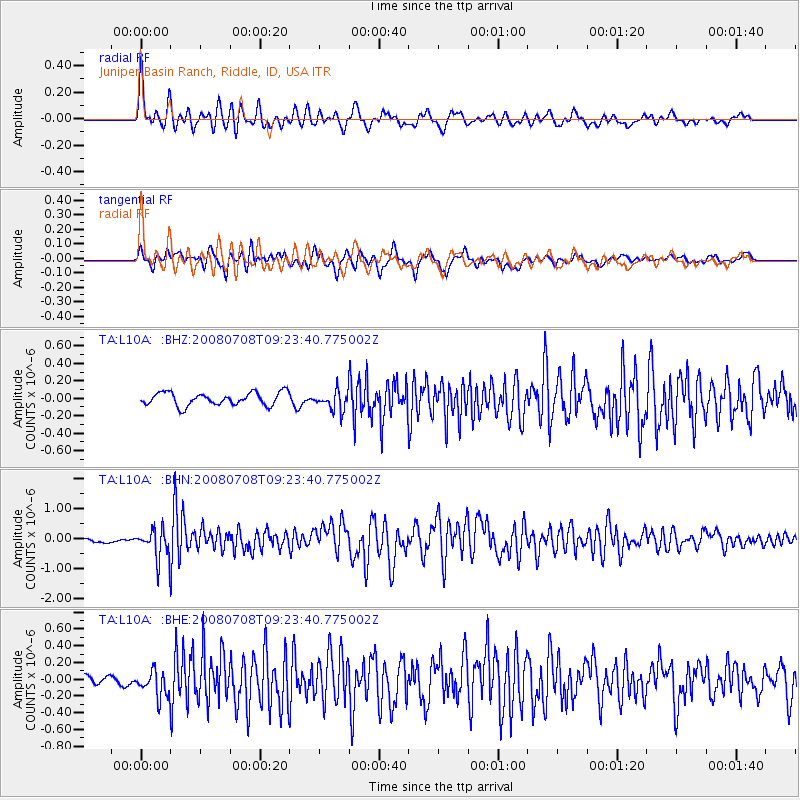
Signal To Noise
| Channel | StoN | STA | LTA |
| TA:L10A: :BHN:20080708T09:23:40.775002Z | 5.570175 | 4.962775E-7 | 8.909549E-8 |
| TA:L10A: :BHE:20080708T09:23:40.775002Z | 2.647495 | 1.5797309E-7 | 5.966889E-8 |
| TA:L10A: :BHZ:20080708T09:23:40.775002Z | 1.5100038 | 1.1210582E-7 | 7.424208E-8 |
| Arrivals |
| Ps | 4.9 SECOND |
| PpPs | 17 SECOND |
| PsPs/PpSs | 22 SECOND |


