You are here: Home > Network List > MM - Myanmar National Seismic Network Stations List
> Station TGI Taung Gyi, Myanmar > Earthquake Result Viewer
TGI Taung Gyi, Myanmar - Earthquake Result Viewer
| Earthquake location: |
Mindanao, Philippines |
| Earthquake latitude/longitude: |
6.9/125.2 |
| Earthquake time(UTC): |
2019/10/29 (302) 01:04:46 GMT |
| Earthquake Depth: |
50 km |
| Earthquake Magnitude: |
6.8 Mi |
| Earthquake Catalog/Contributor: |
NEIC PDE/pt |
|
| Network: |
MM Myanmar National Seismic Network |
| Station: |
TGI Taung Gyi, Myanmar |
| Lat/Lon: |
20.77 N/97.03 E |
| Elevation: |
1458 m |
|
| Distance: |
30.6 deg |
| Az: |
299.599 deg |
| Baz: |
112.709 deg |
| Ray Param: |
0.07922986 |
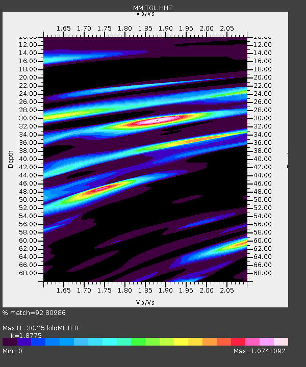
| Estimated Moho Depth: |
30.25 km |
| Estimated Crust Vp/Vs: |
1.88 |
| Assumed Crust Vp: |
6.316 km/s |
| Estimated Crust Vs: |
3.364 km/s |
| Estimated Crust Poisson's Ratio: |
0.30 |
|
| Radial Match: |
92.80986 % |
| Radial Bump: |
302 |
| Transverse Match: |
80.12682 % |
| Transverse Bump: |
400 |
| SOD ConfigId: |
19951751 |
| Insert Time: |
2019-11-12 01:10:26.889 +0000 |
| GWidth: |
2.5 |
| Max Bumps: |
400 |
| Tol: |
0.001 |
|

Signal To Noise
| Channel | StoN | STA | LTA |
| MM:TGI: :HHZ:20191029T01:10:24.820007Z | 16.303528 | 1.3684257E-6 | 8.393433E-8 |
| MM:TGI: :HHN:20191029T01:10:24.820007Z | 6.8100796 | 3.3429325E-7 | 4.9088012E-8 |
| MM:TGI: :HHE:20191029T01:10:24.820007Z | 8.6614065 | 8.006425E-7 | 9.243793E-8 |
| Arrivals |
| Ps | 4.5 SECOND |
| PpPs | 13 SECOND |
| PsPs/PpSs | 17 SECOND |


