You are here: Home > Network List > TA - USArray Transportable Network (new EarthScope stations) Stations List
> Station L10A Juniper Basin Ranch, Riddle, ID, USA > Earthquake Result Viewer
L10A Juniper Basin Ranch, Riddle, ID, USA - Earthquake Result Viewer
| Earthquake location: |
North Of Honduras |
| Earthquake latitude/longitude: |
17.2/-84.8 |
| Earthquake time(UTC): |
2008/03/27 (087) 09:42:57 GMT |
| Earthquake Depth: |
10 km |
| Earthquake Magnitude: |
5.6 MW, 5.1 MS, 5.4 MB, 5.6 MW |
| Earthquake Catalog/Contributor: |
WHDF/NEIC |
|
| Network: |
TA USArray Transportable Network (new EarthScope stations) |
| Station: |
L10A Juniper Basin Ranch, Riddle, ID, USA |
| Lat/Lon: |
42.08 N/116.47 W |
| Elevation: |
1537 m |
|
| Distance: |
36.7 deg |
| Az: |
319.169 deg |
| Baz: |
122.916 deg |
| Ray Param: |
0.07655304 |
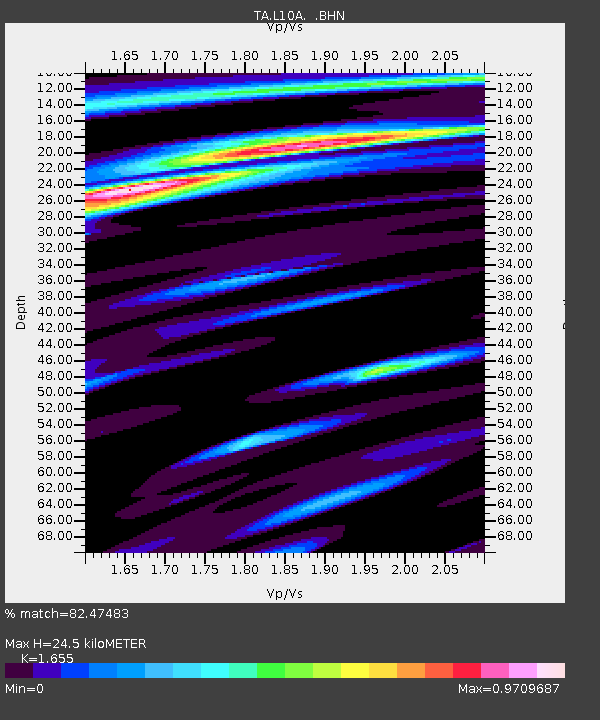
| Estimated Moho Depth: |
24.5 km |
| Estimated Crust Vp/Vs: |
1.65 |
| Assumed Crust Vp: |
6.291 km/s |
| Estimated Crust Vs: |
3.801 km/s |
| Estimated Crust Poisson's Ratio: |
0.21 |
|
| Radial Match: |
82.47483 % |
| Radial Bump: |
400 |
| Transverse Match: |
57.97672 % |
| Transverse Bump: |
400 |
| SOD ConfigId: |
2564 |
| Insert Time: |
2010-03-07 05:19:18.918 +0000 |
| GWidth: |
2.5 |
| Max Bumps: |
400 |
| Tol: |
0.001 |
|
Signal To Noise
| Channel | StoN | STA | LTA |
| TA:L10A: :BHN:20080327T09:49:33.625005Z | 1.6159077 | 1.9371868E-7 | 1.1988226E-7 |
| TA:L10A: :BHE:20080327T09:49:33.625005Z | 4.351594 | 2.7042017E-7 | 6.214279E-8 |
| TA:L10A: :BHZ:20080327T09:49:33.625005Z | 4.236206 | 5.696947E-7 | 1.3448229E-7 |
| Arrivals |
| Ps | 2.8 SECOND |
| PpPs | 9.6 SECOND |
| PsPs/PpSs | 12 SECOND |


