You are here: Home > Network List > TA - USArray Transportable Network (new EarthScope stations) Stations List
> Station C27K Jago River, AK, USA > Earthquake Result Viewer
C27K Jago River, AK, USA - Earthquake Result Viewer
| Earthquake location: |
Mindanao, Philippines |
| Earthquake latitude/longitude: |
6.9/125.2 |
| Earthquake time(UTC): |
2019/10/29 (302) 01:04:46 GMT |
| Earthquake Depth: |
50 km |
| Earthquake Magnitude: |
6.8 Mi |
| Earthquake Catalog/Contributor: |
NEIC PDE/pt |
|
| Network: |
TA USArray Transportable Network (new EarthScope stations) |
| Station: |
C27K Jago River, AK, USA |
| Lat/Lon: |
69.63 N/143.71 W |
| Elevation: |
392 m |
|
| Distance: |
83.9 deg |
| Az: |
20.617 deg |
| Baz: |
273.392 deg |
| Ray Param: |
0.045752667 |
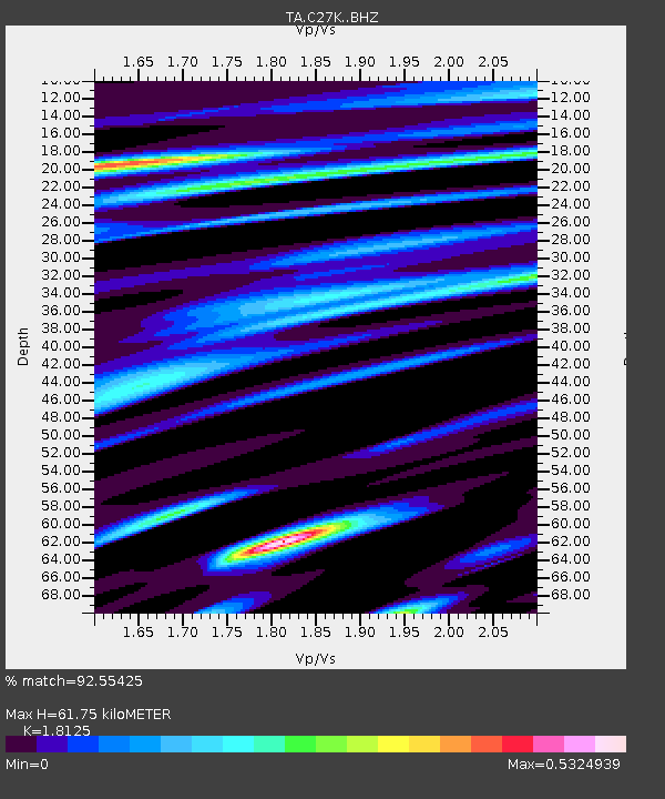
| Estimated Moho Depth: |
61.75 km |
| Estimated Crust Vp/Vs: |
1.81 |
| Assumed Crust Vp: |
6.522 km/s |
| Estimated Crust Vs: |
3.598 km/s |
| Estimated Crust Poisson's Ratio: |
0.28 |
|
| Radial Match: |
92.55425 % |
| Radial Bump: |
400 |
| Transverse Match: |
89.53434 % |
| Transverse Bump: |
400 |
| SOD ConfigId: |
19951751 |
| Insert Time: |
2019-11-12 01:11:12.321 +0000 |
| GWidth: |
2.5 |
| Max Bumps: |
400 |
| Tol: |
0.001 |
|

Signal To Noise
| Channel | StoN | STA | LTA |
| TA:C27K: :BHZ:20191029T01:16:39.474976Z | 1.1433256 | 2.5450606E-7 | 2.2260159E-7 |
| TA:C27K: :BHN:20191029T01:16:39.474976Z | 1.9852726 | 4.89816E-7 | 2.467248E-7 |
| TA:C27K: :BHE:20191029T01:16:39.474976Z | 1.9011668 | 4.06627E-7 | 2.1388287E-7 |
| Arrivals |
| Ps | 7.9 SECOND |
| PpPs | 26 SECOND |
| PsPs/PpSs | 34 SECOND |


