You are here: Home > Network List > TA - USArray Transportable Network (new EarthScope stations) Stations List
> Station L10A Juniper Basin Ranch, Riddle, ID, USA > Earthquake Result Viewer
L10A Juniper Basin Ranch, Riddle, ID, USA - Earthquake Result Viewer
| Earthquake location: |
Solomon Islands |
| Earthquake latitude/longitude: |
-10.9/162.1 |
| Earthquake time(UTC): |
2007/11/27 (331) 11:49:58 GMT |
| Earthquake Depth: |
16 km |
| Earthquake Magnitude: |
5.9 MB, 6.7 MS, 6.6 MW, 6.4 MW |
| Earthquake Catalog/Contributor: |
WHDF/NEIC |
|
| Network: |
TA USArray Transportable Network (new EarthScope stations) |
| Station: |
L10A Juniper Basin Ranch, Riddle, ID, USA |
| Lat/Lon: |
42.08 N/116.47 W |
| Elevation: |
1537 m |
|
| Distance: |
90.9 deg |
| Az: |
47.406 deg |
| Baz: |
256.184 deg |
| Ray Param: |
0.04163653 |
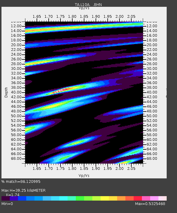
| Estimated Moho Depth: |
39.25 km |
| Estimated Crust Vp/Vs: |
1.74 |
| Assumed Crust Vp: |
6.291 km/s |
| Estimated Crust Vs: |
3.616 km/s |
| Estimated Crust Poisson's Ratio: |
0.25 |
|
| Radial Match: |
86.120995 % |
| Radial Bump: |
340 |
| Transverse Match: |
62.69381 % |
| Transverse Bump: |
400 |
| SOD ConfigId: |
2564 |
| Insert Time: |
2010-03-07 05:19:31.855 +0000 |
| GWidth: |
2.5 |
| Max Bumps: |
400 |
| Tol: |
0.001 |
|
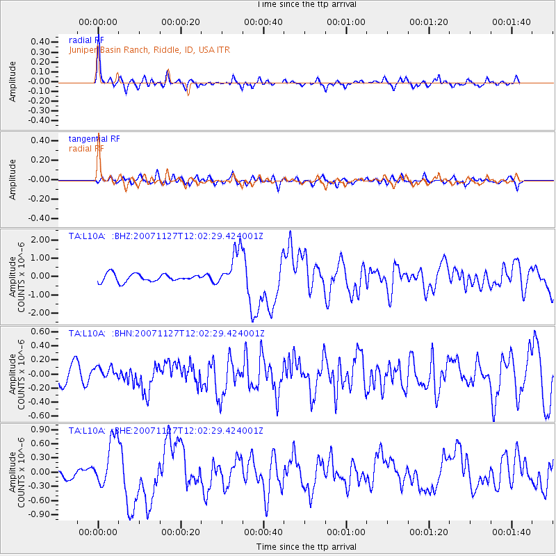
Signal To Noise
| Channel | StoN | STA | LTA |
| TA:L10A: :BHN:20071127T12:02:29.424001Z | 0.49663702 | 9.195689E-8 | 1.8515915E-7 |
| TA:L10A: :BHE:20071127T12:02:29.424001Z | 4.0346165 | 5.301238E-7 | 1.3139385E-7 |
| TA:L10A: :BHZ:20071127T12:02:29.424001Z | 5.119495 | 1.0739305E-6 | 2.0977275E-7 |
| Arrivals |
| Ps | 4.7 SECOND |
| PpPs | 17 SECOND |
| PsPs/PpSs | 21 SECOND |


