You are here: Home > Network List > TA - USArray Transportable Network (new EarthScope stations) Stations List
> Station L10A Juniper Basin Ranch, Riddle, ID, USA > Earthquake Result Viewer
L10A Juniper Basin Ranch, Riddle, ID, USA - Earthquake Result Viewer
| Earthquake location: |
Santa Cruz Islands |
| Earthquake latitude/longitude: |
-11.6/165.8 |
| Earthquake time(UTC): |
2007/09/02 (245) 01:05:18 GMT |
| Earthquake Depth: |
35 km |
| Earthquake Magnitude: |
5.9 MB, 7.3 MS, 7.2 MW, 6.9 ME |
| Earthquake Catalog/Contributor: |
WHDF/NEIC |
|
| Network: |
TA USArray Transportable Network (new EarthScope stations) |
| Station: |
L10A Juniper Basin Ranch, Riddle, ID, USA |
| Lat/Lon: |
42.08 N/116.47 W |
| Elevation: |
1537 m |
|
| Distance: |
88.8 deg |
| Az: |
46.697 deg |
| Baz: |
253.289 deg |
| Ray Param: |
0.04227537 |
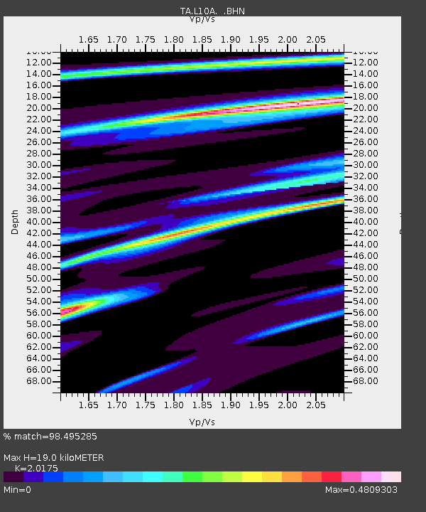
| Estimated Moho Depth: |
19.0 km |
| Estimated Crust Vp/Vs: |
2.02 |
| Assumed Crust Vp: |
6.291 km/s |
| Estimated Crust Vs: |
3.118 km/s |
| Estimated Crust Poisson's Ratio: |
0.34 |
|
| Radial Match: |
98.495285 % |
| Radial Bump: |
204 |
| Transverse Match: |
75.76677 % |
| Transverse Bump: |
400 |
| SOD ConfigId: |
2564 |
| Insert Time: |
2010-03-07 05:20:00.342 +0000 |
| GWidth: |
2.5 |
| Max Bumps: |
400 |
| Tol: |
0.001 |
|

Signal To Noise
| Channel | StoN | STA | LTA |
| TA:L10A: :BHN:20070902T01:17:37.150Z | 3.1441638 | 1.9266179E-7 | 6.1276005E-8 |
| TA:L10A: :BHE:20070902T01:17:37.150Z | 11.888346 | 8.7388213E-7 | 7.3507465E-8 |
| TA:L10A: :BHZ:20070902T01:17:37.150Z | 28.903255 | 2.330444E-6 | 8.062912E-8 |
| Arrivals |
| Ps | 3.1 SECOND |
| PpPs | 9.0 SECOND |
| PsPs/PpSs | 12 SECOND |


