You are here: Home > Network List > RV - Regional Alberta Seismic Observatory for Earthquake Studies Network Stations List
> Station HILA High Level, AB > Earthquake Result Viewer
HILA High Level, AB - Earthquake Result Viewer
| Earthquake location: |
Mindanao, Philippines |
| Earthquake latitude/longitude: |
6.9/125.0 |
| Earthquake time(UTC): |
2019/10/29 (302) 02:42:39 GMT |
| Earthquake Depth: |
10 km |
| Earthquake Magnitude: |
5.8 Mww |
| Earthquake Catalog/Contributor: |
NEIC PDE/us |
|
| Network: |
RV Regional Alberta Seismic Observatory for Earthquake Studies Network |
| Station: |
HILA High Level, AB |
| Lat/Lon: |
58.56 N/117.02 W |
| Elevation: |
329 m |
|
| Distance: |
98.2 deg |
| Az: |
27.89 deg |
| Baz: |
297.621 deg |
| Ray Param: |
0.03996732 |
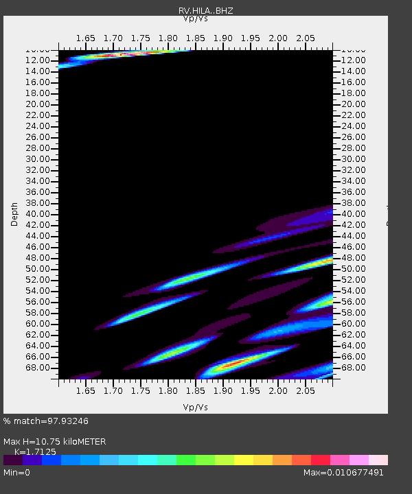
| Estimated Moho Depth: |
10.75 km |
| Estimated Crust Vp/Vs: |
1.71 |
| Assumed Crust Vp: |
6.498 km/s |
| Estimated Crust Vs: |
3.794 km/s |
| Estimated Crust Poisson's Ratio: |
0.24 |
|
| Radial Match: |
97.93246 % |
| Radial Bump: |
314 |
| Transverse Match: |
99.76667 % |
| Transverse Bump: |
43 |
| SOD ConfigId: |
19951751 |
| Insert Time: |
2019-11-12 02:52:21.753 +0000 |
| GWidth: |
2.5 |
| Max Bumps: |
400 |
| Tol: |
0.001 |
|

Signal To Noise
| Channel | StoN | STA | LTA |
| RV:HILA: :BHZ:20191029T02:55:44.600019Z | 1.4690995 | 9.295819E-6 | 6.327563E-6 |
| RV:HILA: :BHN:20191029T02:55:44.600019Z | 1.9121827 | 8.033528E-6 | 4.201235E-6 |
| RV:HILA: :BHE:20191029T02:55:44.600019Z | 1.2365428 | 3.909352E-6 | 3.161518E-6 |
| Arrivals |
| Ps | 1.2 SECOND |
| PpPs | 4.4 SECOND |
| PsPs/PpSs | 5.6 SECOND |


