You are here: Home > Network List > TA - USArray Transportable Network (new EarthScope stations) Stations List
> Station L10A Juniper Basin Ranch, Riddle, ID, USA > Earthquake Result Viewer
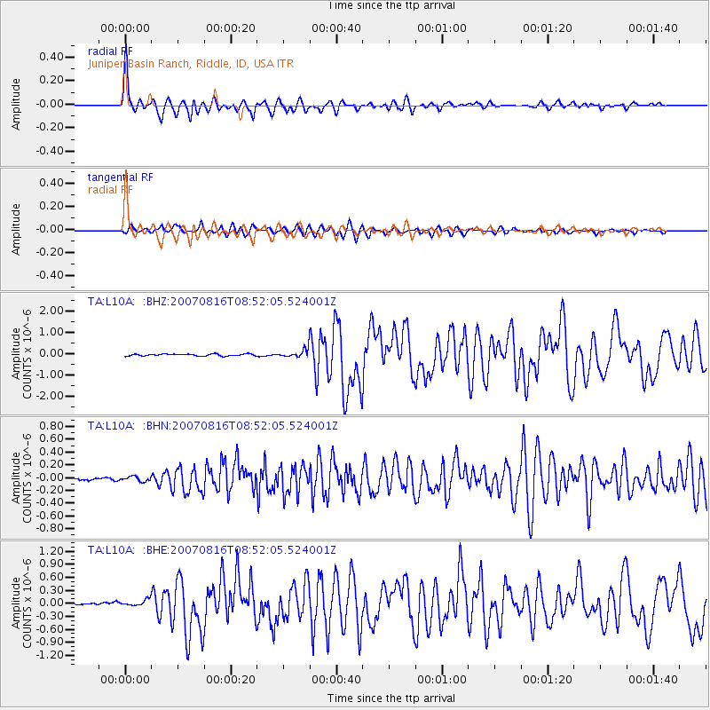
L10A Juniper Basin Ranch, Riddle, ID, USA - Earthquake Result Viewer
| Earthquake location: |
Solomon Islands |
| Earthquake latitude/longitude: |
-9.8/159.5 |
| Earthquake time(UTC): |
2007/08/16 (228) 08:39:27 GMT |
| Earthquake Depth: |
10 km |
| Earthquake Magnitude: |
6.1 MB, 6.7 MS, 6.4 MW |
| Earthquake Catalog/Contributor: |
WHDF/NEIC |
|
| Network: |
TA USArray Transportable Network (new EarthScope stations) |
| Station: |
L10A Juniper Basin Ranch, Riddle, ID, USA |
| Lat/Lon: |
42.08 N/116.47 W |
| Elevation: |
1537 m |
|
| Distance: |
92.1 deg |
| Az: |
47.816 deg |
| Baz: |
258.786 deg |
| Ray Param: |
0.041503344 |
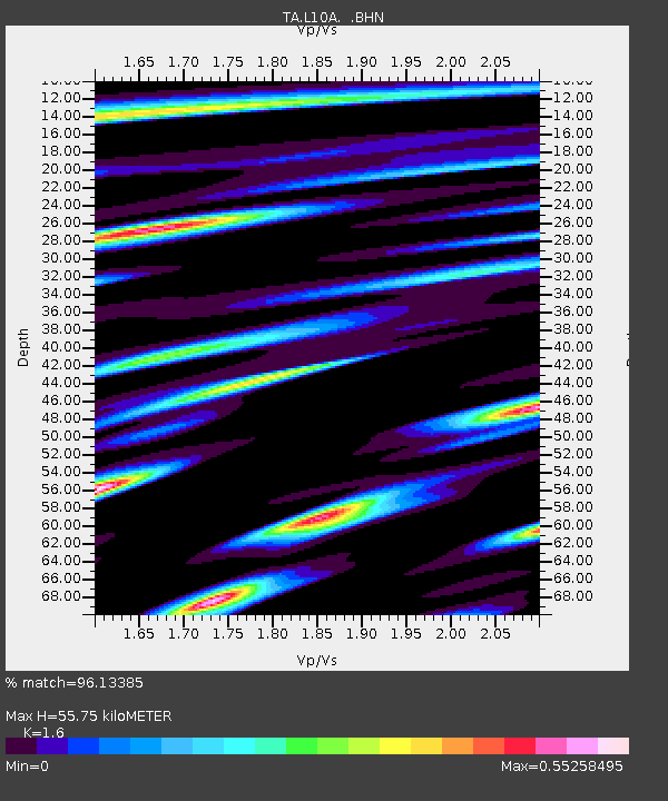
| Estimated Moho Depth: |
55.75 km |
| Estimated Crust Vp/Vs: |
1.60 |
| Assumed Crust Vp: |
6.291 km/s |
| Estimated Crust Vs: |
3.932 km/s |
| Estimated Crust Poisson's Ratio: |
0.18 |
|
| Radial Match: |
96.13385 % |
| Radial Bump: |
400 |
| Transverse Match: |
86.94761 % |
| Transverse Bump: |
400 |
| SOD ConfigId: |
2564 |
| Insert Time: |
2010-03-07 05:20:08.939 +0000 |
| GWidth: |
2.5 |
| Max Bumps: |
400 |
| Tol: |
0.001 |
|
Signal To Noise
| Channel | StoN | STA | LTA |
| TA:L10A: :BHN:20070816T08:52:05.524001Z | 1.3634318 | 3.681026E-8 | 2.6998242E-8 |
| TA:L10A: :BHE:20070816T08:52:05.524001Z | 2.1662388 | 7.676508E-8 | 3.5437036E-8 |
| TA:L10A: :BHZ:20070816T08:52:05.524001Z | 4.345242 | 1.986034E-7 | 4.570595E-8 |
| Arrivals |
| Ps | 5.4 SECOND |
| PpPs | 23 SECOND |
| PsPs/PpSs | 28 SECOND |


