You are here: Home > Network List > TA - USArray Transportable Network (new EarthScope stations) Stations List
> Station L10A Juniper Basin Ranch, Riddle, ID, USA > Earthquake Result Viewer
L10A Juniper Basin Ranch, Riddle, ID, USA - Earthquake Result Viewer
| Earthquake location: |
Santa Cruz Islands |
| Earthquake latitude/longitude: |
-11.4/166.3 |
| Earthquake time(UTC): |
2007/08/12 (224) 12:05:19 GMT |
| Earthquake Depth: |
42 km |
| Earthquake Magnitude: |
5.8 MB, 5.7 MS, 6.0 MW, 6.0 MW |
| Earthquake Catalog/Contributor: |
WHDF/NEIC |
|
| Network: |
TA USArray Transportable Network (new EarthScope stations) |
| Station: |
L10A Juniper Basin Ranch, Riddle, ID, USA |
| Lat/Lon: |
42.08 N/116.47 W |
| Elevation: |
1537 m |
|
| Distance: |
88.3 deg |
| Az: |
46.591 deg |
| Baz: |
253.113 deg |
| Ray Param: |
0.042647276 |
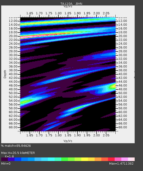
| Estimated Moho Depth: |
20.5 km |
| Estimated Crust Vp/Vs: |
1.60 |
| Assumed Crust Vp: |
6.291 km/s |
| Estimated Crust Vs: |
3.932 km/s |
| Estimated Crust Poisson's Ratio: |
0.18 |
|
| Radial Match: |
85.94626 % |
| Radial Bump: |
275 |
| Transverse Match: |
64.33789 % |
| Transverse Bump: |
380 |
| SOD ConfigId: |
2564 |
| Insert Time: |
2010-03-07 05:20:16.861 +0000 |
| GWidth: |
2.5 |
| Max Bumps: |
400 |
| Tol: |
0.001 |
|
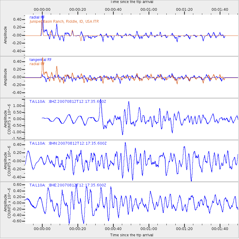
Signal To Noise
| Channel | StoN | STA | LTA |
| TA:L10A: :BHN:20070812T12:17:35.600Z | 0.54865754 | 7.3158134E-8 | 1.3334024E-7 |
| TA:L10A: :BHE:20070812T12:17:35.600Z | 3.59864 | 2.6964622E-7 | 7.4930036E-8 |
| TA:L10A: :BHZ:20070812T12:17:35.600Z | 3.193875 | 6.202253E-7 | 1.941921E-7 |
| Arrivals |
| Ps | 2.0 SECOND |
| PpPs | 8.3 SECOND |
| PsPs/PpSs | 10 SECOND |


