You are here: Home > Network List > TA - USArray Transportable Network (new EarthScope stations) Stations List
> Station L10A Juniper Basin Ranch, Riddle, ID, USA > Earthquake Result Viewer
L10A Juniper Basin Ranch, Riddle, ID, USA - Earthquake Result Viewer

| Earthquake location: |
Andreanof Islands, Aleutian Is. |
| Earthquake latitude/longitude: |
51.3/-180.0 |
| Earthquake time(UTC): |
2007/08/02 (214) 03:21:42 GMT |
| Earthquake Depth: |
21 km |
| Earthquake Magnitude: |
6.3 MB, 6.6 MS, 6.7 MW, 6.6 MW |
| Earthquake Catalog/Contributor: |
WHDF/NEIC |
|
| Network: |
TA USArray Transportable Network (new EarthScope stations) |
| Station: |
L10A Juniper Basin Ranch, Riddle, ID, USA |
| Lat/Lon: |
42.08 N/116.47 W |
| Elevation: |
1537 m |
|
| Distance: |
43.3 deg |
| Az: |
76.456 deg |
| Baz: |
304.945 deg |
| Ray Param: |
0.072636575 |
| Estimated Moho Depth: |
39.25 km |
| Estimated Crust Vp/Vs: |
1.75 |
| Assumed Crust Vp: |
6.291 km/s |
| Estimated Crust Vs: |
3.6 km/s |
| Estimated Crust Poisson's Ratio: |
0.26 |
|
| Radial Match: |
80.755585 % |
| Radial Bump: |
400 |
| Transverse Match: |
68.79226 % |
| Transverse Bump: |
400 |
| SOD ConfigId: |
2564 |
| Insert Time: |
2010-03-07 05:20:19.092 +0000 |
| GWidth: |
2.5 |
| Max Bumps: |
400 |
| Tol: |
0.001 |
|
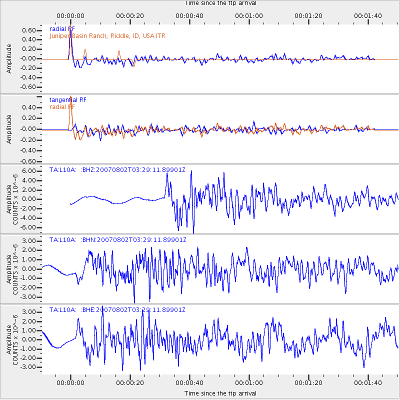
Signal To Noise
| Channel | StoN | STA | LTA |
| TA:L10A: :BHN:20070802T03:29:11.89901Z | 2.5889404 | 7.479346E-7 | 2.8889605E-7 |
| TA:L10A: :BHE:20070802T03:29:11.89901Z | 0.902394 | 8.5319954E-7 | 9.4548454E-7 |
| TA:L10A: :BHZ:20070802T03:29:11.89901Z | 3.8669732 | 2.0327072E-6 | 5.256585E-7 |
| Arrivals |
| Ps | 5.0 SECOND |
| PpPs | 16 SECOND |
| PsPs/PpSs | 21 SECOND |


