You are here: Home > Network List > GS - US Geological Survey Networks Stations List
> Station OK051 E0350 and S34600 Roads, Ralston, OK > Earthquake Result Viewer
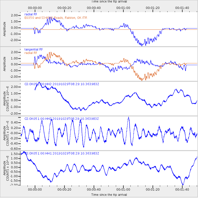
OK051 E0350 and S34600 Roads, Ralston, OK - Earthquake Result Viewer
*The percent match for this event was below the threshold and hence no stack was calculated.
| Earthquake location: |
South Of Fiji Islands |
| Earthquake latitude/longitude: |
-23.4/-177.1 |
| Earthquake time(UTC): |
2019/10/29 (302) 08:16:32 GMT |
| Earthquake Depth: |
162 km |
| Earthquake Magnitude: |
5.5 Mww |
| Earthquake Catalog/Contributor: |
NEIC PDE/us |
|
| Network: |
GS US Geological Survey Networks |
| Station: |
OK051 E0350 and S34600 Roads, Ralston, OK |
| Lat/Lon: |
36.51 N/96.84 W |
| Elevation: |
263 m |
|
| Distance: |
96.2 deg |
| Az: |
53.019 deg |
| Baz: |
245.634 deg |
| Ray Param: |
$rayparam |
*The percent match for this event was below the threshold and hence was not used in the summary stack. |
|
| Radial Match: |
59.32376 % |
| Radial Bump: |
400 |
| Transverse Match: |
43.594048 % |
| Transverse Bump: |
400 |
| SOD ConfigId: |
19951751 |
| Insert Time: |
2019-11-12 08:25:20.566 +0000 |
| GWidth: |
2.5 |
| Max Bumps: |
400 |
| Tol: |
0.001 |
|
Signal To Noise
| Channel | StoN | STA | LTA |
| GS:OK051:00:HHZ:20191029T08:29:10.363983Z | 1.6183894 | 2.542393E-7 | 1.5709402E-7 |
| GS:OK051:00:HH1:20191029T08:29:10.363983Z | 1.1661432 | 1.1610621E-6 | 9.956428E-7 |
| GS:OK051:00:HH2:20191029T08:29:10.363983Z | 2.605569 | 2.5886472E-6 | 9.935056E-7 |
| Arrivals |
| Ps | |
| PpPs | |
| PsPs/PpSs | |


