You are here: Home > Network List > TA - USArray Transportable Network (new EarthScope stations) Stations List
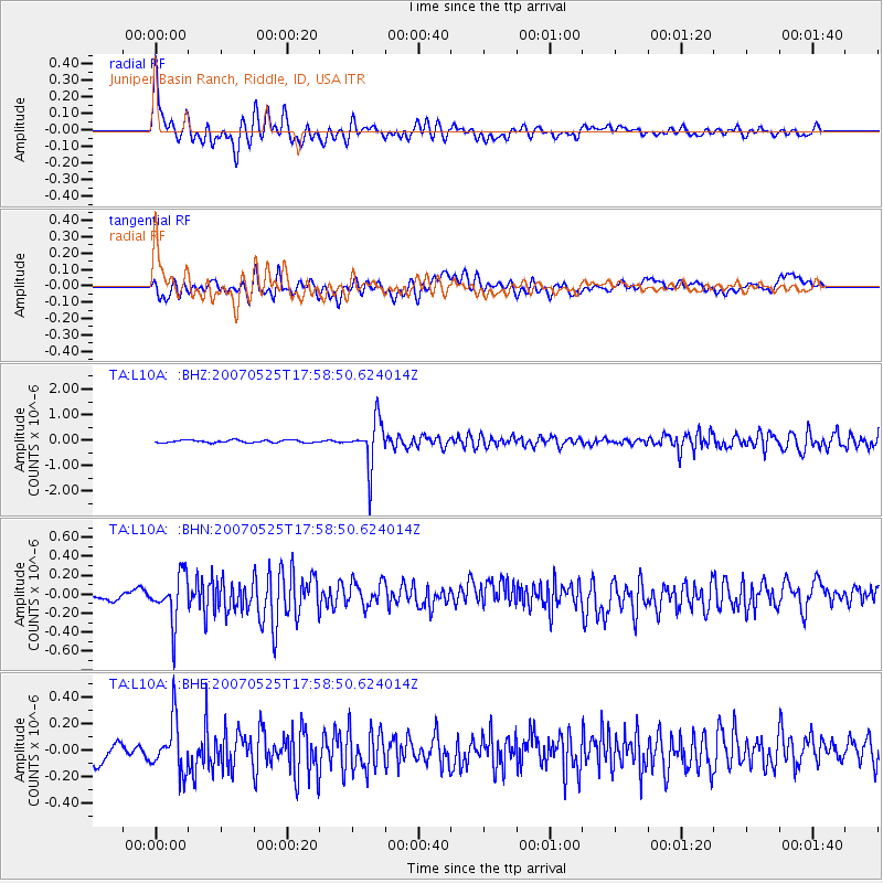
> Station L10A Juniper Basin Ranch, Riddle, ID, USA > Earthquake Result Viewer
L10A Juniper Basin Ranch, Riddle, ID, USA - Earthquake Result Viewer
| Earthquake location: |
Chile-Argentina Border Region |
| Earthquake latitude/longitude: |
-24.2/-67.0 |
| Earthquake time(UTC): |
2007/05/25 (145) 17:47:31 GMT |
| Earthquake Depth: |
180 km |
| Earthquake Magnitude: |
5.5 MB, 5.9 MW, 5.9 MW |
| Earthquake Catalog/Contributor: |
WHDF/NEIC |
|
| Network: |
TA USArray Transportable Network (new EarthScope stations) |
| Station: |
L10A Juniper Basin Ranch, Riddle, ID, USA |
| Lat/Lon: |
42.08 N/116.47 W |
| Elevation: |
1537 m |
|
| Distance: |
80.2 deg |
| Az: |
324.975 deg |
| Baz: |
135.263 deg |
| Ray Param: |
0.047976125 |
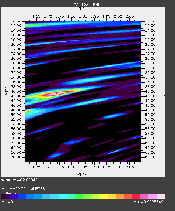
| Estimated Moho Depth: |
40.75 km |
| Estimated Crust Vp/Vs: |
1.74 |
| Assumed Crust Vp: |
6.291 km/s |
| Estimated Crust Vs: |
3.626 km/s |
| Estimated Crust Poisson's Ratio: |
0.25 |
|
| Radial Match: |
82.02943 % |
| Radial Bump: |
400 |
| Transverse Match: |
66.9876 % |
| Transverse Bump: |
400 |
| SOD ConfigId: |
2564 |
| Insert Time: |
2010-03-07 05:20:47.657 +0000 |
| GWidth: |
2.5 |
| Max Bumps: |
400 |
| Tol: |
0.001 |
|
Signal To Noise
| Channel | StoN | STA | LTA |
| TA:L10A: :BHN:20070525T17:58:50.624014Z | 4.873038 | 2.4885787E-7 | 5.1068323E-8 |
| TA:L10A: :BHE:20070525T17:58:50.624014Z | 3.123726 | 1.875819E-7 | 6.0050695E-8 |
| TA:L10A: :BHZ:20070525T17:58:50.624014Z | 17.71179 | 8.904477E-7 | 5.027429E-8 |
| Arrivals |
| Ps | 4.9 SECOND |
| PpPs | 17 SECOND |
| PsPs/PpSs | 22 SECOND |


