You are here: Home > Network List > TA - USArray Transportable Network (new EarthScope stations) Stations List
> Station L10A Juniper Basin Ranch, Riddle, ID, USA > Earthquake Result Viewer
L10A Juniper Basin Ranch, Riddle, ID, USA - Earthquake Result Viewer
| Earthquake location: |
Near West Coast Of Honshu, Japan |
| Earthquake latitude/longitude: |
37.3/136.6 |
| Earthquake time(UTC): |
2007/03/25 (084) 00:41:57 GMT |
| Earthquake Depth: |
8.0 km |
| Earthquake Magnitude: |
6.1 MB, 6.8 MS, 6.7 MW, 6.6 MW |
| Earthquake Catalog/Contributor: |
WHDF/NEIC |
|
| Network: |
TA USArray Transportable Network (new EarthScope stations) |
| Station: |
L10A Juniper Basin Ranch, Riddle, ID, USA |
| Lat/Lon: |
42.08 N/116.47 W |
| Elevation: |
1537 m |
|
| Distance: |
76.7 deg |
| Az: |
47.041 deg |
| Baz: |
308.416 deg |
| Ray Param: |
0.050831817 |
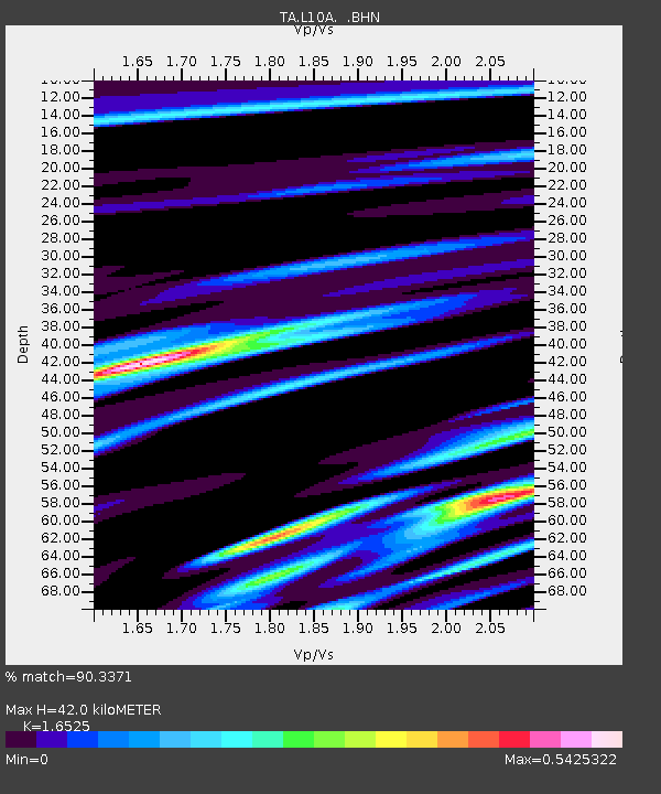
| Estimated Moho Depth: |
42.0 km |
| Estimated Crust Vp/Vs: |
1.65 |
| Assumed Crust Vp: |
6.291 km/s |
| Estimated Crust Vs: |
3.807 km/s |
| Estimated Crust Poisson's Ratio: |
0.21 |
|
| Radial Match: |
90.3371 % |
| Radial Bump: |
400 |
| Transverse Match: |
73.396164 % |
| Transverse Bump: |
400 |
| SOD ConfigId: |
2564 |
| Insert Time: |
2010-03-07 05:20:49.001 +0000 |
| GWidth: |
2.5 |
| Max Bumps: |
400 |
| Tol: |
0.001 |
|
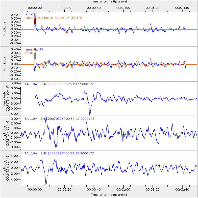
Signal To Noise
| Channel | StoN | STA | LTA |
| TA:L10A: :BHN:20070325T00:53:17.900017Z | 1.3226526 | 7.393095E-7 | 5.589597E-7 |
| TA:L10A: :BHE:20070325T00:53:17.900017Z | 1.3850207 | 1.4773616E-6 | 1.0666711E-6 |
| TA:L10A: :BHZ:20070325T00:53:17.900017Z | 1.049136 | 3.142428E-6 | 2.995253E-6 |
| Arrivals |
| Ps | 4.5 SECOND |
| PpPs | 17 SECOND |
| PsPs/PpSs | 22 SECOND |


