You are here: Home > Network List > TA - USArray Transportable Network (new EarthScope stations) Stations List
> Station L10A Juniper Basin Ranch, Riddle, ID, USA > Earthquake Result Viewer
L10A Juniper Basin Ranch, Riddle, ID, USA - Earthquake Result Viewer

| Earthquake location: |
Primor'ye, Russia |
| Earthquake latitude/longitude: |
43.2/133.5 |
| Earthquake time(UTC): |
2007/03/09 (068) 03:22:42 GMT |
| Earthquake Depth: |
441 km |
| Earthquake Magnitude: |
6.1 MB, 6.0 MW, 6.0 MW |
| Earthquake Catalog/Contributor: |
WHDF/NEIC |
|
| Network: |
TA USArray Transportable Network (new EarthScope stations) |
| Station: |
L10A Juniper Basin Ranch, Riddle, ID, USA |
| Lat/Lon: |
42.08 N/116.47 W |
| Elevation: |
1537 m |
|
| Distance: |
74.4 deg |
| Az: |
46.588 deg |
| Baz: |
314.499 deg |
| Ray Param: |
0.051042344 |
| Estimated Moho Depth: |
40.0 km |
| Estimated Crust Vp/Vs: |
1.75 |
| Assumed Crust Vp: |
6.291 km/s |
| Estimated Crust Vs: |
3.59 km/s |
| Estimated Crust Poisson's Ratio: |
0.26 |
|
| Radial Match: |
81.552925 % |
| Radial Bump: |
400 |
| Transverse Match: |
77.851616 % |
| Transverse Bump: |
400 |
| SOD ConfigId: |
2564 |
| Insert Time: |
2010-03-07 05:20:53.432 +0000 |
| GWidth: |
2.5 |
| Max Bumps: |
400 |
| Tol: |
0.001 |
|
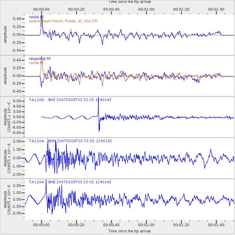
Signal To Noise
| Channel | StoN | STA | LTA |
| TA:L10A: :BHN:20070309T03:33:03.124014Z | 3.2894077 | 7.184809E-7 | 2.1842257E-7 |
| TA:L10A: :BHE:20070309T03:33:03.124014Z | 1.3831004 | 8.272486E-7 | 5.9811174E-7 |
| TA:L10A: :BHZ:20070309T03:33:03.124014Z | 5.4035296 | 2.910027E-6 | 5.385419E-7 |
| Arrivals |
| Ps | 4.9 SECOND |
| PpPs | 17 SECOND |
| PsPs/PpSs | 22 SECOND |


