You are here: Home > Network List > US - United States National Seismic Network Stations List
> Station AMTX Amarillo, Texas, USA > Earthquake Result Viewer
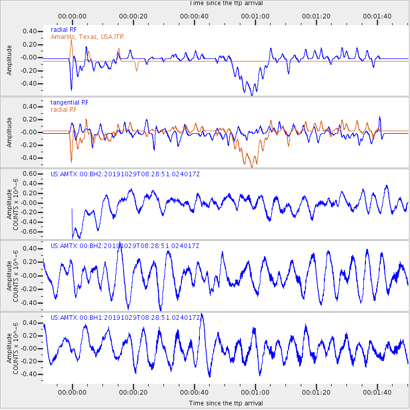
AMTX Amarillo, Texas, USA - Earthquake Result Viewer
*The percent match for this event was below the threshold and hence no stack was calculated.
| Earthquake location: |
South Of Fiji Islands |
| Earthquake latitude/longitude: |
-23.4/-177.1 |
| Earthquake time(UTC): |
2019/10/29 (302) 08:16:32 GMT |
| Earthquake Depth: |
162 km |
| Earthquake Magnitude: |
5.5 Mww |
| Earthquake Catalog/Contributor: |
NEIC PDE/us |
|
| Network: |
US United States National Seismic Network |
| Station: |
AMTX Amarillo, Texas, USA |
| Lat/Lon: |
34.53 N/101.41 W |
| Elevation: |
1010 m |
|
| Distance: |
92.0 deg |
| Az: |
53.177 deg |
| Baz: |
242.977 deg |
| Ray Param: |
$rayparam |
*The percent match for this event was below the threshold and hence was not used in the summary stack. |
|
| Radial Match: |
33.038277 % |
| Radial Bump: |
400 |
| Transverse Match: |
52.176918 % |
| Transverse Bump: |
400 |
| SOD ConfigId: |
19951751 |
| Insert Time: |
2019-11-12 08:28:28.067 +0000 |
| GWidth: |
2.5 |
| Max Bumps: |
400 |
| Tol: |
0.001 |
|
Signal To Noise
| Channel | StoN | STA | LTA |
| US:AMTX:00:BHZ:20191029T08:28:51.024017Z | 0.7421129 | 1.6340788E-7 | 2.2019276E-7 |
| US:AMTX:00:BH1:20191029T08:28:51.024017Z | 1.4270114 | 2.6735657E-7 | 1.8735419E-7 |
| US:AMTX:00:BH2:20191029T08:28:51.024017Z | 0.6492813 | 1.7301043E-7 | 2.6646453E-7 |
| Arrivals |
| Ps | |
| PpPs | |
| PsPs/PpSs | |


