You are here: Home > Network List > TA - USArray Transportable Network (new EarthScope stations) Stations List
> Station L10A Juniper Basin Ranch, Riddle, ID, USA > Earthquake Result Viewer
L10A Juniper Basin Ranch, Riddle, ID, USA - Earthquake Result Viewer
| Earthquake location: |
Kuril Islands |
| Earthquake latitude/longitude: |
45.4/151.0 |
| Earthquake time(UTC): |
2008/07/06 (188) 09:08:20 GMT |
| Earthquake Depth: |
10 km |
| Earthquake Magnitude: |
5.8 MB, 5.4 MS, 5.7 MW, 5.7 MW |
| Earthquake Catalog/Contributor: |
WHDF/NEIC |
|
| Network: |
TA USArray Transportable Network (new EarthScope stations) |
| Station: |
L10A Juniper Basin Ranch, Riddle, ID, USA |
| Lat/Lon: |
42.08 N/116.47 W |
| Elevation: |
1537 m |
|
| Distance: |
63.2 deg |
| Az: |
56.397 deg |
| Baz: |
307.965 deg |
| Ray Param: |
0.05970197 |
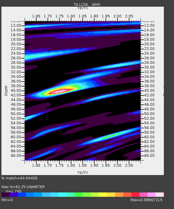
| Estimated Moho Depth: |
40.25 km |
| Estimated Crust Vp/Vs: |
1.75 |
| Assumed Crust Vp: |
6.291 km/s |
| Estimated Crust Vs: |
3.605 km/s |
| Estimated Crust Poisson's Ratio: |
0.26 |
|
| Radial Match: |
84.94485 % |
| Radial Bump: |
400 |
| Transverse Match: |
74.70486 % |
| Transverse Bump: |
400 |
| SOD ConfigId: |
2504 |
| Insert Time: |
2010-03-07 05:21:16.675 +0000 |
| GWidth: |
2.5 |
| Max Bumps: |
400 |
| Tol: |
0.001 |
|

Signal To Noise
| Channel | StoN | STA | LTA |
| TA:L10A: :BHN:20080706T09:18:17.550024Z | 3.5309958 | 1.5126135E-7 | 4.2838153E-8 |
| TA:L10A: :BHE:20080706T09:18:17.550024Z | 1.4870216 | 6.8560006E-8 | 4.610559E-8 |
| TA:L10A: :BHZ:20080706T09:18:17.550024Z | 2.5763166 | 9.580367E-8 | 3.7186297E-8 |
| Arrivals |
| Ps | 5.0 SECOND |
| PpPs | 17 SECOND |
| PsPs/PpSs | 22 SECOND |


