You are here: Home > Network List > TA - USArray Transportable Network (new EarthScope stations) Stations List
> Station L10A Juniper Basin Ranch, Riddle, ID, USA > Earthquake Result Viewer
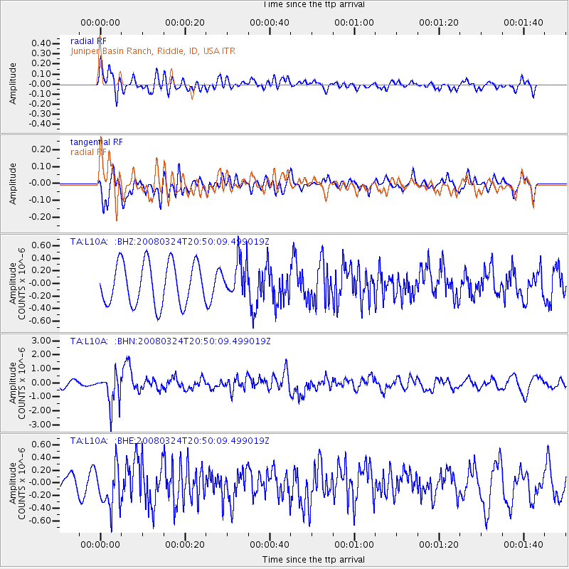
L10A Juniper Basin Ranch, Riddle, ID, USA - Earthquake Result Viewer
*The percent match for this event was below the threshold and hence no stack was calculated.
| Earthquake location: |
Chile-Bolivia Border Region |
| Earthquake latitude/longitude: |
-20.0/-69.0 |
| Earthquake time(UTC): |
2008/03/24 (084) 20:39:07 GMT |
| Earthquake Depth: |
120 km |
| Earthquake Magnitude: |
5.7 MB, 6.2 MW, 6.1 MW |
| Earthquake Catalog/Contributor: |
WHDF/NEIC |
|
| Network: |
TA USArray Transportable Network (new EarthScope stations) |
| Station: |
L10A Juniper Basin Ranch, Riddle, ID, USA |
| Lat/Lon: |
42.08 N/116.47 W |
| Elevation: |
1537 m |
|
| Distance: |
75.8 deg |
| Az: |
325.51 deg |
| Baz: |
134.348 deg |
| Ray Param: |
$rayparam |
*The percent match for this event was below the threshold and hence was not used in the summary stack. |
|
| Radial Match: |
73.08163 % |
| Radial Bump: |
400 |
| Transverse Match: |
60.112183 % |
| Transverse Bump: |
400 |
| SOD ConfigId: |
2504 |
| Insert Time: |
2010-03-07 05:21:21.777 +0000 |
| GWidth: |
2.5 |
| Max Bumps: |
400 |
| Tol: |
0.001 |
|
Signal To Noise
| Channel | StoN | STA | LTA |
| TA:L10A: :BHN:20080324T20:50:09.499019Z | 4.605126 | 1.1106515E-6 | 2.4117722E-7 |
| TA:L10A: :BHE:20080324T20:50:09.499019Z | 2.4837193 | 3.343282E-7 | 1.3460789E-7 |
| TA:L10A: :BHZ:20080324T20:50:09.499019Z | 0.869588 | 2.897648E-7 | 3.3322078E-7 |
| Arrivals |
| Ps | |
| PpPs | |
| PsPs/PpSs | |


