You are here: Home > Network List > TA - USArray Transportable Network (new EarthScope stations) Stations List
> Station L10A Juniper Basin Ranch, Riddle, ID, USA > Earthquake Result Viewer
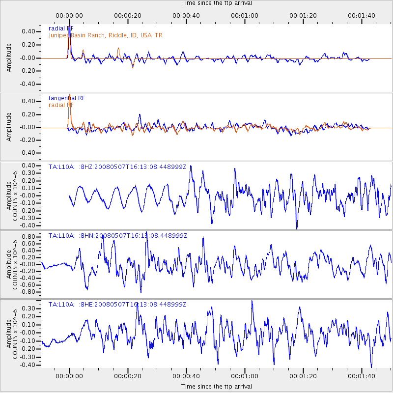
L10A Juniper Basin Ranch, Riddle, ID, USA - Earthquake Result Viewer
*The percent match for this event was below the threshold and hence no stack was calculated.
| Earthquake location: |
Near East Coast Of Honshu, Japan |
| Earthquake latitude/longitude: |
36.2/141.5 |
| Earthquake time(UTC): |
2008/05/07 (128) 16:02:02 GMT |
| Earthquake Depth: |
19 km |
| Earthquake Magnitude: |
5.7 MB, 6.2 MW, 6.2 MW |
| Earthquake Catalog/Contributor: |
WHDF/NEIC |
|
| Network: |
TA USArray Transportable Network (new EarthScope stations) |
| Station: |
L10A Juniper Basin Ranch, Riddle, ID, USA |
| Lat/Lon: |
42.08 N/116.47 W |
| Elevation: |
1537 m |
|
| Distance: |
74.5 deg |
| Az: |
49.091 deg |
| Baz: |
304.782 deg |
| Ray Param: |
$rayparam |
*The percent match for this event was below the threshold and hence was not used in the summary stack. |
|
| Radial Match: |
72.73459 % |
| Radial Bump: |
400 |
| Transverse Match: |
61.171246 % |
| Transverse Bump: |
400 |
| SOD ConfigId: |
2504 |
| Insert Time: |
2010-03-07 05:21:26.688 +0000 |
| GWidth: |
2.5 |
| Max Bumps: |
400 |
| Tol: |
0.001 |
|
Signal To Noise
| Channel | StoN | STA | LTA |
| TA:L10A: :BHN:20080507T16:13:08.448999Z | 1.8986292 | 1.7603709E-7 | 9.271799E-8 |
| TA:L10A: :BHE:20080507T16:13:08.448999Z | 0.7018703 | 8.593677E-8 | 1.2243967E-7 |
| TA:L10A: :BHZ:20080507T16:13:08.448999Z | 1.0222917 | 9.325428E-8 | 9.122081E-8 |
| Arrivals |
| Ps | |
| PpPs | |
| PsPs/PpSs | |


