You are here: Home > Network List > TA - USArray Transportable Network (new EarthScope stations) Stations List
> Station L10A Juniper Basin Ranch, Riddle, ID, USA > Earthquake Result Viewer
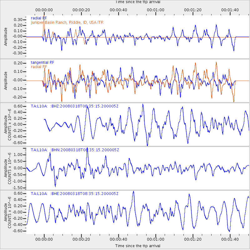
L10A Juniper Basin Ranch, Riddle, ID, USA - Earthquake Result Viewer
*The percent match for this event was below the threshold and hence no stack was calculated.
| Earthquake location: |
Kermadec Islands, New Zealand |
| Earthquake latitude/longitude: |
-29.3/-177.4 |
| Earthquake time(UTC): |
2008/03/18 (078) 08:22:47 GMT |
| Earthquake Depth: |
25 km |
| Earthquake Magnitude: |
5.8 MB, 6.1 MS, 6.2 MW, 6.2 MW |
| Earthquake Catalog/Contributor: |
WHDF/NEIC |
|
| Network: |
TA USArray Transportable Network (new EarthScope stations) |
| Station: |
L10A Juniper Basin Ranch, Riddle, ID, USA |
| Lat/Lon: |
42.08 N/116.47 W |
| Elevation: |
1537 m |
|
| Distance: |
90.5 deg |
| Az: |
40.614 deg |
| Baz: |
229.828 deg |
| Ray Param: |
$rayparam |
*The percent match for this event was below the threshold and hence was not used in the summary stack. |
|
| Radial Match: |
53.889885 % |
| Radial Bump: |
392 |
| Transverse Match: |
72.93034 % |
| Transverse Bump: |
337 |
| SOD ConfigId: |
2504 |
| Insert Time: |
2010-03-07 05:21:44.793 +0000 |
| GWidth: |
2.5 |
| Max Bumps: |
400 |
| Tol: |
0.001 |
|
Signal To Noise
| Channel | StoN | STA | LTA |
| TA:L10A: :BHN:20080318T08:35:15.200005Z | 3.9738734 | 5.465558E-7 | 1.3753728E-7 |
| TA:L10A: :BHE:20080318T08:35:15.200005Z | 0.79999787 | 2.0223402E-7 | 2.527932E-7 |
| TA:L10A: :BHZ:20080318T08:35:15.200005Z | 0.6292616 | 1.3456933E-7 | 2.1385276E-7 |
| Arrivals |
| Ps | |
| PpPs | |
| PsPs/PpSs | |


