You are here: Home > Network List > TA - USArray Transportable Network (new EarthScope stations) Stations List
> Station L10A Juniper Basin Ranch, Riddle, ID, USA > Earthquake Result Viewer
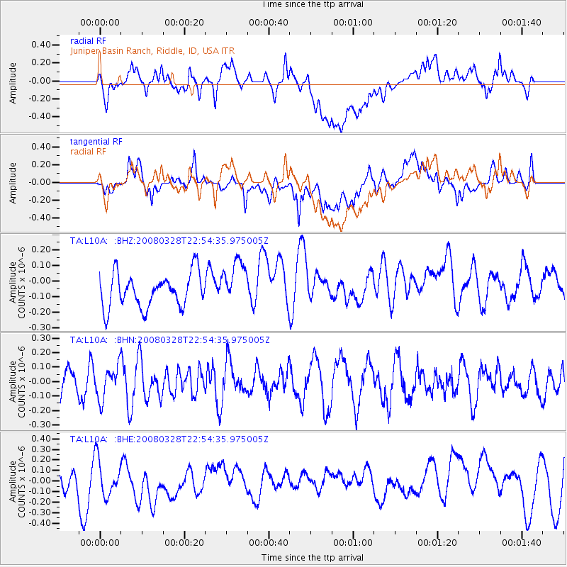
L10A Juniper Basin Ranch, Riddle, ID, USA - Earthquake Result Viewer
*The percent match for this event was below the threshold and hence no stack was calculated.
| Earthquake location: |
Philippine Islands Region |
| Earthquake latitude/longitude: |
20.3/121.9 |
| Earthquake time(UTC): |
2008/03/28 (088) 22:41:32 GMT |
| Earthquake Depth: |
10 km |
| Earthquake Magnitude: |
5.6 MB, 5.6 MS, 5.8 MW, 5.8 MW |
| Earthquake Catalog/Contributor: |
WHDF/NEIC |
|
| Network: |
TA USArray Transportable Network (new EarthScope stations) |
| Station: |
L10A Juniper Basin Ranch, Riddle, ID, USA |
| Lat/Lon: |
42.08 N/116.47 W |
| Elevation: |
1537 m |
|
| Distance: |
97.8 deg |
| Az: |
39.807 deg |
| Baz: |
306.155 deg |
| Ray Param: |
$rayparam |
*The percent match for this event was below the threshold and hence was not used in the summary stack. |
|
| Radial Match: |
51.925045 % |
| Radial Bump: |
400 |
| Transverse Match: |
48.73562 % |
| Transverse Bump: |
400 |
| SOD ConfigId: |
2504 |
| Insert Time: |
2010-03-07 05:21:45.999 +0000 |
| GWidth: |
2.5 |
| Max Bumps: |
400 |
| Tol: |
0.001 |
|
Signal To Noise
| Channel | StoN | STA | LTA |
| TA:L10A: :BHN:20080328T22:54:35.975005Z | 1.1266041 | 1.1571469E-7 | 1.0271105E-7 |
| TA:L10A: :BHE:20080328T22:54:35.975005Z | 1.0114557 | 1.9545142E-7 | 1.9323774E-7 |
| TA:L10A: :BHZ:20080328T22:54:35.975005Z | 1.3836015 | 1.4957475E-7 | 1.0810536E-7 |
| Arrivals |
| Ps | |
| PpPs | |
| PsPs/PpSs | |


