You are here: Home > Network List > TA - USArray Transportable Network (new EarthScope stations) Stations List
> Station L15K Ungalak Mountain, AK, USA > Earthquake Result Viewer
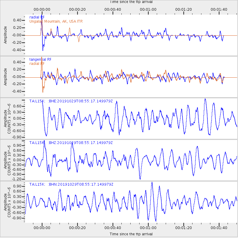
L15K Ungalak Mountain, AK, USA - Earthquake Result Viewer
*The percent match for this event was below the threshold and hence no stack was calculated.
| Earthquake location: |
Solomon Islands |
| Earthquake latitude/longitude: |
-6.3/154.8 |
| Earthquake time(UTC): |
2019/10/29 (302) 08:44:09 GMT |
| Earthquake Depth: |
69 km |
| Earthquake Magnitude: |
5.8 Mww |
| Earthquake Catalog/Contributor: |
NEIC PDE/us |
|
| Network: |
TA USArray Transportable Network (new EarthScope stations) |
| Station: |
L15K Ungalak Mountain, AK, USA |
| Lat/Lon: |
61.68 N/161.49 W |
| Elevation: |
219 m |
|
| Distance: |
75.7 deg |
| Az: |
19.876 deg |
| Baz: |
225.123 deg |
| Ray Param: |
$rayparam |
*The percent match for this event was below the threshold and hence was not used in the summary stack. |
|
| Radial Match: |
49.302166 % |
| Radial Bump: |
400 |
| Transverse Match: |
50.502377 % |
| Transverse Bump: |
400 |
| SOD ConfigId: |
19951751 |
| Insert Time: |
2019-11-12 08:55:56.351 +0000 |
| GWidth: |
2.5 |
| Max Bumps: |
400 |
| Tol: |
0.001 |
|
Signal To Noise
| Channel | StoN | STA | LTA |
| TA:L15K: :BHZ:20191029T08:55:17.149979Z | 1.9271278 | 6.026338E-7 | 3.1271088E-7 |
| TA:L15K: :BHN:20191029T08:55:17.149979Z | 0.5093826 | 1.8809648E-7 | 3.6926363E-7 |
| TA:L15K: :BHE:20191029T08:55:17.149979Z | 0.7645153 | 2.47617E-7 | 3.2388758E-7 |
| Arrivals |
| Ps | |
| PpPs | |
| PsPs/PpSs | |


