You are here: Home > Network List > TA - USArray Transportable Network (new EarthScope stations) Stations List
> Station L10A Juniper Basin Ranch, Riddle, ID, USA > Earthquake Result Viewer
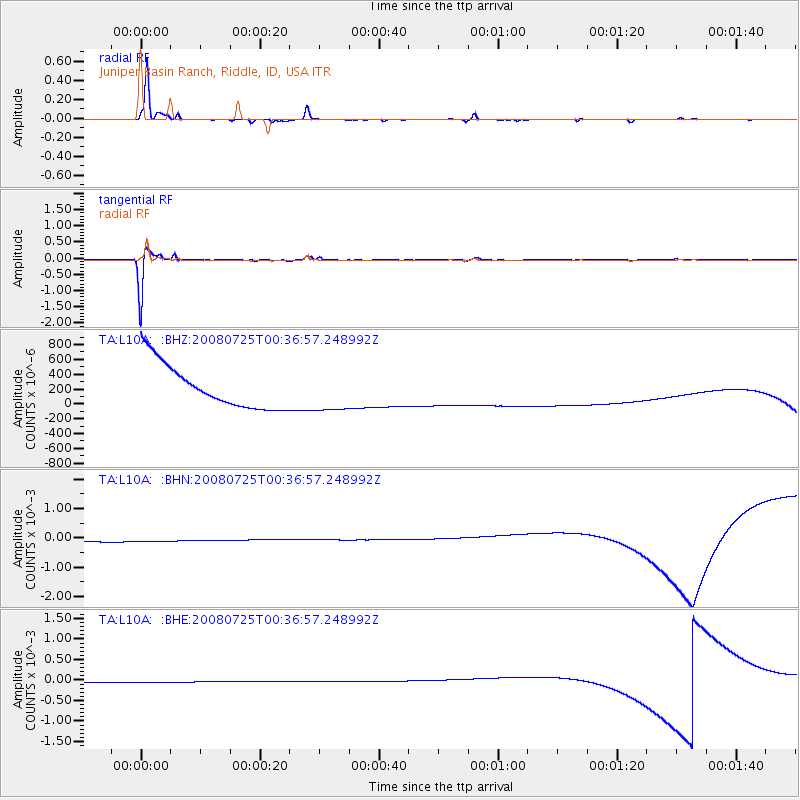
L10A Juniper Basin Ranch, Riddle, ID, USA - Earthquake Result Viewer
*The percent match for this event was below the threshold and hence no stack was calculated.
| Earthquake location: |
Rat Islands, Aleutian Islands |
| Earthquake latitude/longitude: |
51.3/179.0 |
| Earthquake time(UTC): |
2008/07/25 (207) 00:29:22 GMT |
| Earthquake Depth: |
21 km |
| Earthquake Magnitude: |
5.7 MB, 5.5 MS, 5.9 MW, 5.9 MW |
| Earthquake Catalog/Contributor: |
WHDF/NEIC |
|
| Network: |
TA USArray Transportable Network (new EarthScope stations) |
| Station: |
L10A Juniper Basin Ranch, Riddle, ID, USA |
| Lat/Lon: |
42.08 N/116.47 W |
| Elevation: |
1537 m |
|
| Distance: |
43.9 deg |
| Az: |
75.778 deg |
| Baz: |
305.134 deg |
| Ray Param: |
$rayparam |
*The percent match for this event was below the threshold and hence was not used in the summary stack. |
|
| Radial Match: |
92.71345 % |
| Radial Bump: |
137 |
| Transverse Match: |
89.05165 % |
| Transverse Bump: |
248 |
| SOD ConfigId: |
2504 |
| Insert Time: |
2010-03-07 05:21:57.396 +0000 |
| GWidth: |
2.5 |
| Max Bumps: |
400 |
| Tol: |
0.001 |
|
Signal To Noise
| Channel | StoN | STA | LTA |
| TA:L10A: :BHN:20080725T00:36:57.248992Z | 0.9159851 | 2.9231355E-4 | 3.1912478E-4 |
| TA:L10A: :BHE:20080725T00:36:57.248992Z | 0.91916144 | 1.3369022E-4 | 1.4544802E-4 |
| TA:L10A: :BHZ:20080725T00:36:57.248992Z | 0.9160668 | 2.7330976E-4 | 2.9835134E-4 |
| Arrivals |
| Ps | |
| PpPs | |
| PsPs/PpSs | |


