You are here: Home > Network List > TA - USArray Transportable Network (new EarthScope stations) Stations List
> Station R33M Jennings River, BC, CAN > Earthquake Result Viewer
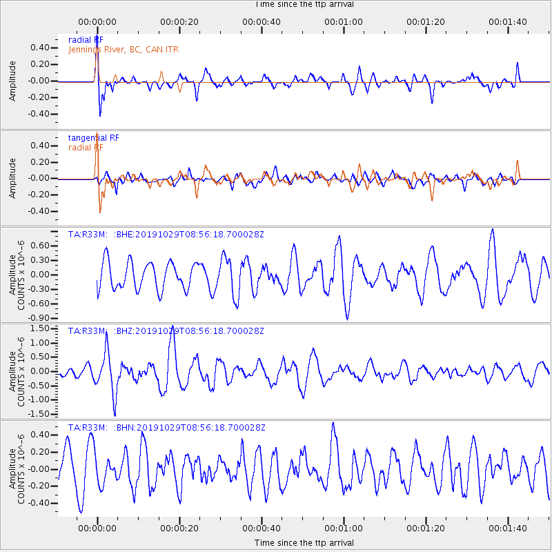
R33M Jennings River, BC, CAN - Earthquake Result Viewer
*The percent match for this event was below the threshold and hence no stack was calculated.
| Earthquake location: |
Solomon Islands |
| Earthquake latitude/longitude: |
-6.3/154.8 |
| Earthquake time(UTC): |
2019/10/29 (302) 08:44:09 GMT |
| Earthquake Depth: |
69 km |
| Earthquake Magnitude: |
5.8 Mww |
| Earthquake Catalog/Contributor: |
NEIC PDE/us |
|
| Network: |
TA USArray Transportable Network (new EarthScope stations) |
| Station: |
R33M Jennings River, BC, CAN |
| Lat/Lon: |
59.39 N/130.97 W |
| Elevation: |
1437 m |
|
| Distance: |
87.5 deg |
| Az: |
29.529 deg |
| Baz: |
253.233 deg |
| Ray Param: |
$rayparam |
*The percent match for this event was below the threshold and hence was not used in the summary stack. |
|
| Radial Match: |
72.890076 % |
| Radial Bump: |
400 |
| Transverse Match: |
54.042713 % |
| Transverse Bump: |
400 |
| SOD ConfigId: |
19951751 |
| Insert Time: |
2019-11-12 08:56:16.898 +0000 |
| GWidth: |
2.5 |
| Max Bumps: |
400 |
| Tol: |
0.001 |
|
Signal To Noise
| Channel | StoN | STA | LTA |
| TA:R33M: :BHZ:20191029T08:56:18.700028Z | 2.9673164 | 7.372453E-7 | 2.4845522E-7 |
| TA:R33M: :BHN:20191029T08:56:18.700028Z | 0.81194305 | 1.6196314E-7 | 1.9947599E-7 |
| TA:R33M: :BHE:20191029T08:56:18.700028Z | 1.4459279 | 3.9941648E-7 | 2.762354E-7 |
| Arrivals |
| Ps | |
| PpPs | |
| PsPs/PpSs | |


