You are here: Home > Network List > AK - Alaska Regional Network Stations List
> Station ANM Anvil Mountian > Earthquake Result Viewer
ANM Anvil Mountian - Earthquake Result Viewer
| Earthquake location: |
Mindanao, Philippines |
| Earthquake latitude/longitude: |
7.1/125.3 |
| Earthquake time(UTC): |
2019/10/31 (304) 01:11:20 GMT |
| Earthquake Depth: |
22 km |
| Earthquake Magnitude: |
6.8 Mi |
| Earthquake Catalog/Contributor: |
NEIC PDE/at |
|
| Network: |
AK Alaska Regional Network |
| Station: |
ANM Anvil Mountian |
| Lat/Lon: |
64.56 N/165.37 W |
| Elevation: |
330 m |
|
| Distance: |
74.8 deg |
| Az: |
24.756 deg |
| Baz: |
254.191 deg |
| Ray Param: |
0.052060954 |
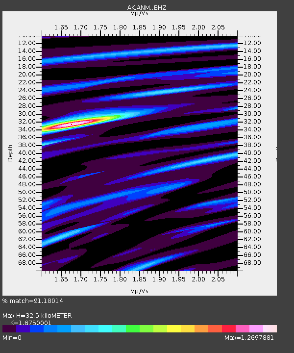
| Estimated Moho Depth: |
32.5 km |
| Estimated Crust Vp/Vs: |
1.68 |
| Assumed Crust Vp: |
6.276 km/s |
| Estimated Crust Vs: |
3.747 km/s |
| Estimated Crust Poisson's Ratio: |
0.22 |
|
| Radial Match: |
91.18014 % |
| Radial Bump: |
400 |
| Transverse Match: |
84.46295 % |
| Transverse Bump: |
400 |
| SOD ConfigId: |
19951751 |
| Insert Time: |
2019-11-14 01:17:38.695 +0000 |
| GWidth: |
2.5 |
| Max Bumps: |
400 |
| Tol: |
0.001 |
|

Signal To Noise
| Channel | StoN | STA | LTA |
| AK:ANM: :BHZ:20191031T01:22:27.268005Z | 4.9866915 | 8.825061E-7 | 1.7697226E-7 |
| AK:ANM: :BHN:20191031T01:22:27.268005Z | 1.2432626 | 2.480888E-7 | 1.9954658E-7 |
| AK:ANM: :BHE:20191031T01:22:27.268005Z | 1.8232757 | 3.3249563E-7 | 1.8236169E-7 |
| Arrivals |
| Ps | 3.6 SECOND |
| PpPs | 13 SECOND |
| PsPs/PpSs | 17 SECOND |


