You are here: Home > Network List > AU - Australian Seismological Centre Stations List
> Station PSAB2 Pilbara Seismic Array Element B2 > Earthquake Result Viewer
PSAB2 Pilbara Seismic Array Element B2 - Earthquake Result Viewer
| Earthquake location: |
South Of Fiji Islands |
| Earthquake latitude/longitude: |
-23.2/-178.8 |
| Earthquake time(UTC): |
2017/02/24 (055) 17:28:44 GMT |
| Earthquake Depth: |
415 km |
| Earthquake Magnitude: |
6.9 mww |
| Earthquake Catalog/Contributor: |
NEIC PDE/us |
|
| Network: |
AU Australian Seismological Centre |
| Station: |
PSAB2 Pilbara Seismic Array Element B2 |
| Lat/Lon: |
21.55 S/119.86 E |
| Elevation: |
302 m |
|
| Distance: |
56.3 deg |
| Az: |
258.876 deg |
| Baz: |
104.189 deg |
| Ray Param: |
0.0626419 |
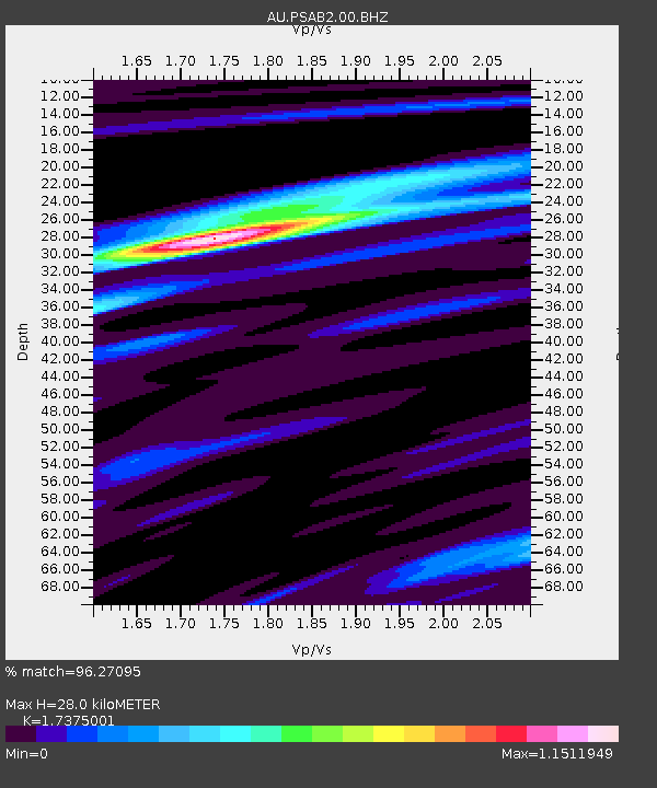
| Estimated Moho Depth: |
28.0 km |
| Estimated Crust Vp/Vs: |
1.74 |
| Assumed Crust Vp: |
6.464 km/s |
| Estimated Crust Vs: |
3.72 km/s |
| Estimated Crust Poisson's Ratio: |
0.25 |
|
| Radial Match: |
96.27095 % |
| Radial Bump: |
300 |
| Transverse Match: |
83.88312 % |
| Transverse Bump: |
400 |
| SOD ConfigId: |
1992691 |
| Insert Time: |
2017-03-10 17:29:18.557 +0000 |
| GWidth: |
2.5 |
| Max Bumps: |
400 |
| Tol: |
0.001 |
|

Signal To Noise
| Channel | StoN | STA | LTA |
| AU:PSAB2:00:BHZ:20170224T17:37:13.893987Z | 3.1282983 | 1.1384693E-6 | 3.6392606E-7 |
| AU:PSAB2:00:BH1:20170224T17:37:13.893987Z | 1.5640403 | 3.4823924E-7 | 2.2265361E-7 |
| AU:PSAB2:00:BH2:20170224T17:37:13.893987Z | 2.6047108 | 4.576527E-7 | 1.7570193E-7 |
| Arrivals |
| Ps | 3.4 SECOND |
| PpPs | 11 SECOND |
| PsPs/PpSs | 15 SECOND |


