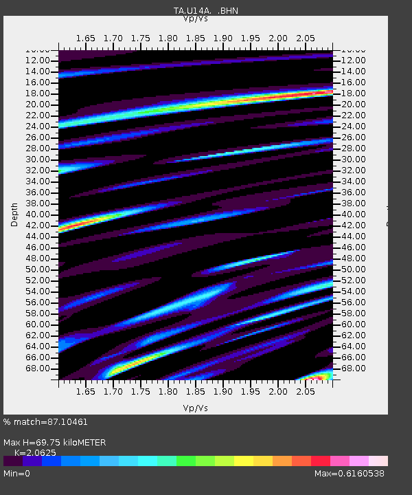
U14A Mt Trumbull, AZ, USA - Earthquake Result Viewer
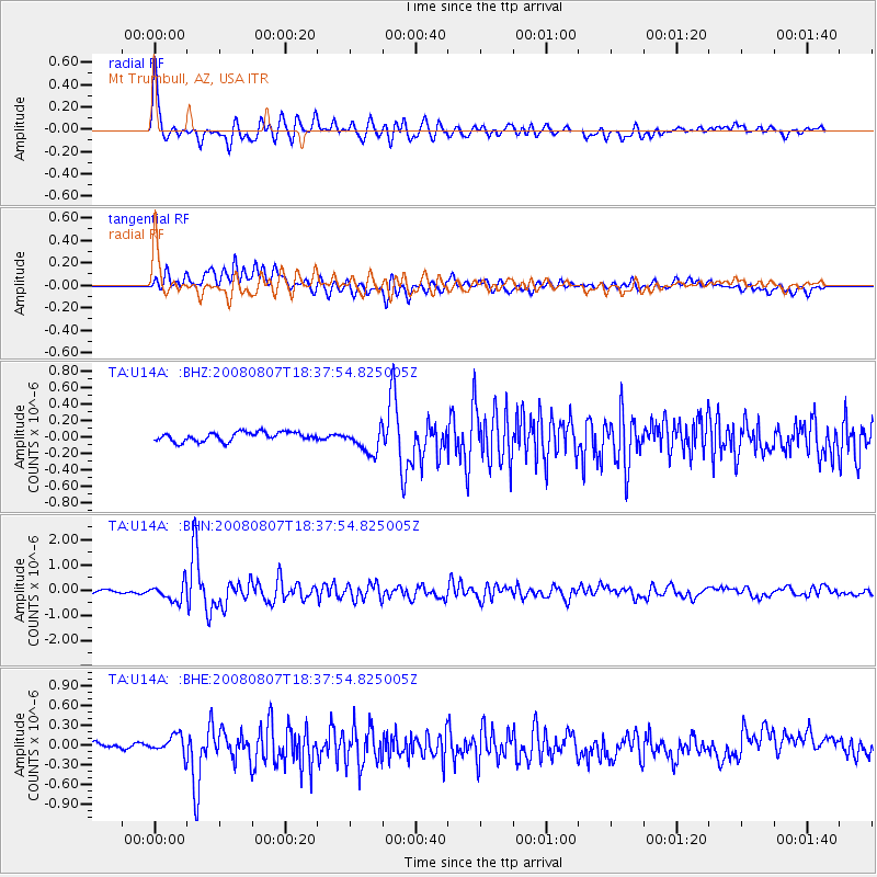
Earthquake location: Andreanof Islands, Aleutian Is.
Earthquake latitude/longitude: 52.2/-175.7
Earthquake time(UTC): 2008/08/07 (220) 18:30:03 GMT
Earthquake Depth: 12 km
Earthquake Magnitude: 5.6 MB, 5.5 MS, 5.8 MW, 5.8 MW
Earthquake Catalog/Contributor: WHDF/NEIC
Network: TA USArray Transportable Network (new EarthScope stations)
Station: U14A Mt Trumbull, AZ, USA
Lat/Lon: 36.42 N/113.18 W
Elevation: 1916 m
Distance: 45.9 deg
Az: 84.404 deg
Baz: 310.573 deg
Ray Param: 0.07094327
Estimated Moho Depth: 69.75 km
Estimated Crust Vp/Vs: 2.06
Assumed Crust Vp: 6.194 km/s
Estimated Crust Vs: 3.003 km/s
Estimated Crust Poisson's Ratio: 0.35
Radial Match: 87.10461 %
Radial Bump: 400
Transverse Match: 53.243557 %
Transverse Bump: 400
SOD ConfigId: 2504
Insert Time: 2010-03-07 05:22:14.269 +0000
GWidth: 2.5
Max Bumps: 400
Tol: 0.001

Signal To Noise

ChannelStoNSTALTA
TA:U14A: :BHN:20080807T18:37:54.825005Z6.75453953.4347548E-75.085106E-8
TA:U14A: :BHE:20080807T18:37:54.825005Z3.3065041.4082156E-74.258926E-8
TA:U14A: :BHZ:20080807T18:37:54.825005Z2.8224941.5571109E-75.5167906E-8
Arrivals
Ps13 SECOND
PpPs33 SECOND
PsPs/PpSs45 SECOND