You are here: Home > Network List > AU - Australian Seismological Centre Stations List
> Station PSAC1 Pilbara Seismic Array Element C1 > Earthquake Result Viewer
PSAC1 Pilbara Seismic Array Element C1 - Earthquake Result Viewer
| Earthquake location: |
South Of Fiji Islands |
| Earthquake latitude/longitude: |
-23.2/-178.8 |
| Earthquake time(UTC): |
2017/02/24 (055) 17:28:44 GMT |
| Earthquake Depth: |
415 km |
| Earthquake Magnitude: |
6.9 mww |
| Earthquake Catalog/Contributor: |
NEIC PDE/us |
|
| Network: |
AU Australian Seismological Centre |
| Station: |
PSAC1 Pilbara Seismic Array Element C1 |
| Lat/Lon: |
21.53 S/119.81 E |
| Elevation: |
303 m |
|
| Distance: |
56.4 deg |
| Az: |
258.887 deg |
| Baz: |
104.214 deg |
| Ray Param: |
0.06260927 |
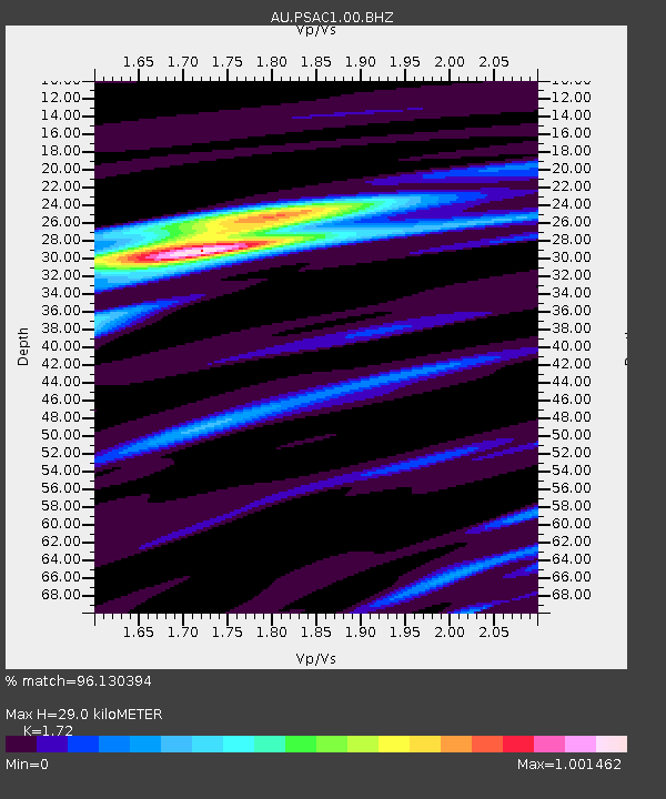
| Estimated Moho Depth: |
29.0 km |
| Estimated Crust Vp/Vs: |
1.72 |
| Assumed Crust Vp: |
6.464 km/s |
| Estimated Crust Vs: |
3.758 km/s |
| Estimated Crust Poisson's Ratio: |
0.24 |
|
| Radial Match: |
96.130394 % |
| Radial Bump: |
267 |
| Transverse Match: |
79.882195 % |
| Transverse Bump: |
400 |
| SOD ConfigId: |
1992691 |
| Insert Time: |
2017-03-10 17:29:21.100 +0000 |
| GWidth: |
2.5 |
| Max Bumps: |
400 |
| Tol: |
0.001 |
|

Signal To Noise
| Channel | StoN | STA | LTA |
| AU:PSAC1:00:BHZ:20170224T17:37:14.243993Z | 3.8517878 | 1.1791392E-6 | 3.0612776E-7 |
| AU:PSAC1:00:BH1:20170224T17:37:14.243993Z | 1.5578499 | 3.1007727E-7 | 1.9904182E-7 |
| AU:PSAC1:00:BH2:20170224T17:37:14.243993Z | 5.422828 | 6.707535E-7 | 1.2369071E-7 |
| Arrivals |
| Ps | 3.4 SECOND |
| PpPs | 12 SECOND |
| PsPs/PpSs | 15 SECOND |


