You are here: Home > Network List > TA - USArray Transportable Network (new EarthScope stations) Stations List
> Station U14A Mt Trumbull, AZ, USA > Earthquake Result Viewer
U14A Mt Trumbull, AZ, USA - Earthquake Result Viewer

| Earthquake location: |
Sakhalin, Russia |
| Earthquake latitude/longitude: |
47.1/141.8 |
| Earthquake time(UTC): |
2007/08/02 (214) 02:37:42 GMT |
| Earthquake Depth: |
5.0 km |
| Earthquake Magnitude: |
6.2 MS, 5.3 MB, 6.2 MW, 6.2 MW |
| Earthquake Catalog/Contributor: |
WHDF/NEIC |
|
| Network: |
TA USArray Transportable Network (new EarthScope stations) |
| Station: |
U14A Mt Trumbull, AZ, USA |
| Lat/Lon: |
36.42 N/113.18 W |
| Elevation: |
1916 m |
|
| Distance: |
73.2 deg |
| Az: |
54.465 deg |
| Baz: |
316.447 deg |
| Ray Param: |
0.053168345 |
| Estimated Moho Depth: |
68.0 km |
| Estimated Crust Vp/Vs: |
2.07 |
| Assumed Crust Vp: |
6.194 km/s |
| Estimated Crust Vs: |
3.0 km/s |
| Estimated Crust Poisson's Ratio: |
0.35 |
|
| Radial Match: |
82.14165 % |
| Radial Bump: |
400 |
| Transverse Match: |
60.86892 % |
| Transverse Bump: |
400 |
| SOD ConfigId: |
2564 |
| Insert Time: |
2010-03-07 05:22:48.907 +0000 |
| GWidth: |
2.5 |
| Max Bumps: |
400 |
| Tol: |
0.001 |
|
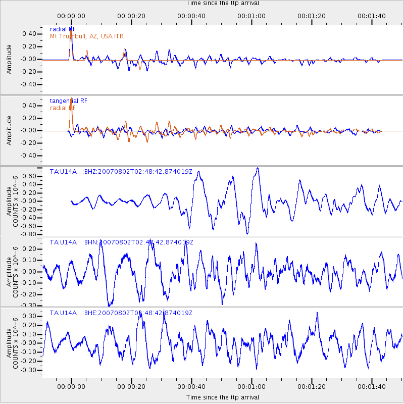
Signal To Noise
| Channel | StoN | STA | LTA |
| TA:U14A: :BHN:20070802T02:48:42.874019Z | 1.3814564 | 6.517344E-8 | 4.717734E-8 |
| TA:U14A: :BHE:20070802T02:48:42.874019Z | 0.7149578 | 5.1863573E-8 | 7.254075E-8 |
| TA:U14A: :BHZ:20070802T02:48:42.874019Z | 1.7941862 | 1.2424783E-7 | 6.925025E-8 |
| Arrivals |
| Ps | 12 SECOND |
| PpPs | 33 SECOND |
| PsPs/PpSs | 45 SECOND |


