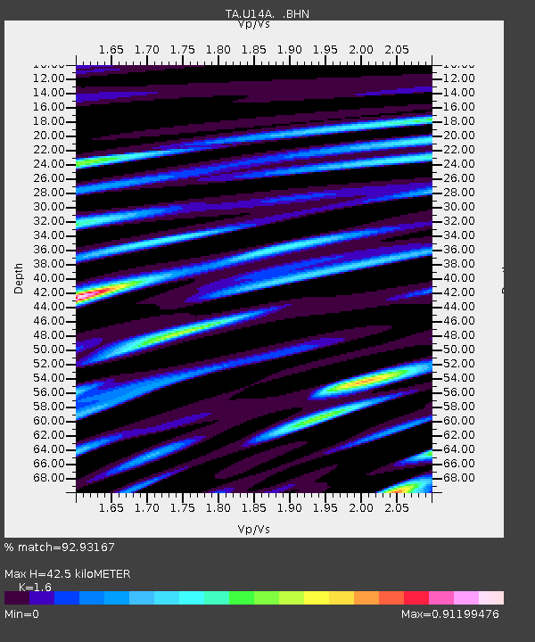
U14A Mt Trumbull, AZ, USA - Earthquake Result Viewer
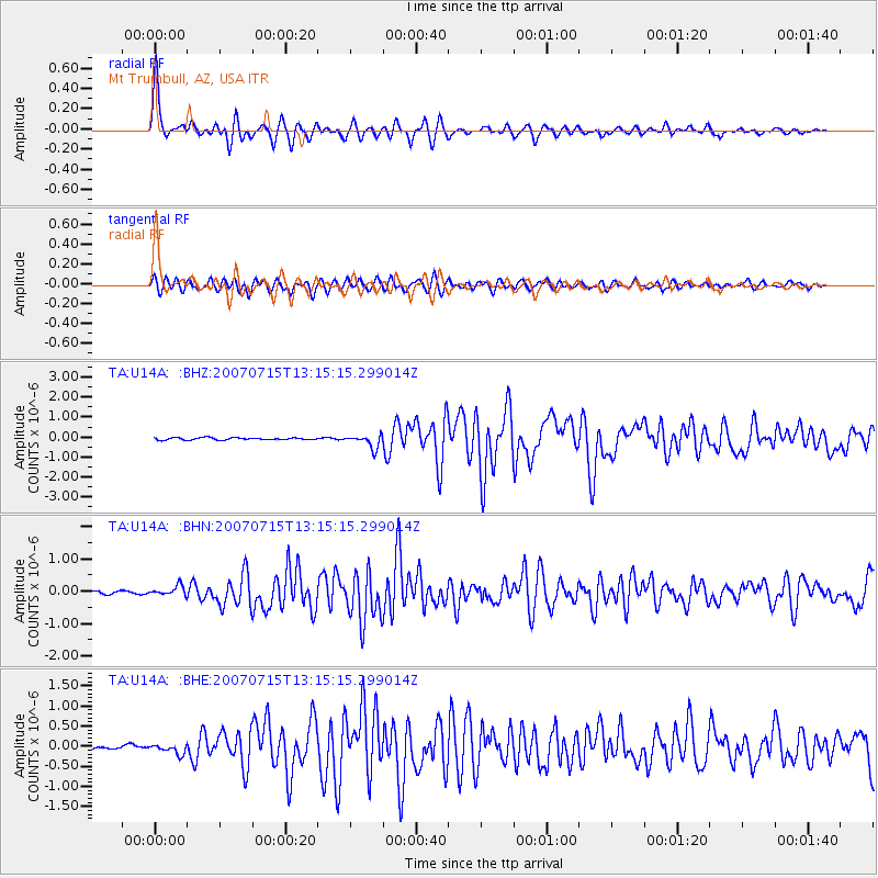
Earthquake location: Fox Islands, Aleutian Islands
Earthquake latitude/longitude: 52.5/-168.0
Earthquake time(UTC): 2007/07/15 (196) 13:08:00 GMT
Earthquake Depth: 10 km
Earthquake Magnitude: 5.8 MB, 5.9 MS, 6.1 MW, 6.0 MW
Earthquake Catalog/Contributor: WHDF/NEIC
Network: TA USArray Transportable Network (new EarthScope stations)
Station: U14A Mt Trumbull, AZ, USA
Lat/Lon: 36.42 N/113.18 W
Elevation: 1916 m
Distance: 41.3 deg
Az: 90.496 deg
Baz: 310.69 deg
Ray Param: 0.07389445
Estimated Moho Depth: 42.5 km
Estimated Crust Vp/Vs: 1.60
Assumed Crust Vp: 6.194 km/s
Estimated Crust Vs: 3.871 km/s
Estimated Crust Poisson's Ratio: 0.18
Radial Match: 92.93167 %
Radial Bump: 400
Transverse Match: 86.56425 %
Transverse Bump: 400
SOD ConfigId: 2564
Insert Time: 2010-03-07 05:23:00.733 +0000
GWidth: 2.5
Max Bumps: 400
Tol: 0.001

Signal To Noise

ChannelStoNSTALTA
TA:U14A: :BHN:20070715T13:15:15.299014Z2.6721941.4641118E-75.4790625E-8
TA:U14A: :BHE:20070715T13:15:15.299014Z2.31922131.2165964E-75.2457104E-8
TA:U14A: :BHZ:20070715T13:15:15.299014Z5.9220693.297863E-75.5687686E-8
Arrivals
Ps4.4 SECOND
PpPs17 SECOND
PsPs/PpSs21 SECOND