You are here: Home > Network List > TA - USArray Transportable Network (new EarthScope stations) Stations List
> Station U14A Mt Trumbull, AZ, USA > Earthquake Result Viewer
U14A Mt Trumbull, AZ, USA - Earthquake Result Viewer
| Earthquake location: |
Solomon Islands |
| Earthquake latitude/longitude: |
-8.5/157.0 |
| Earthquake time(UTC): |
2007/04/01 (091) 20:39:56 GMT |
| Earthquake Depth: |
10 km |
| Earthquake Magnitude: |
6.8 MB, 7.9 MS, 8.1 MW, 7.7 ME |
| Earthquake Catalog/Contributor: |
WHDF/NEIC |
|
| Network: |
TA USArray Transportable Network (new EarthScope stations) |
| Station: |
U14A Mt Trumbull, AZ, USA |
| Lat/Lon: |
36.42 N/113.18 W |
| Elevation: |
1916 m |
|
| Distance: |
94.8 deg |
| Az: |
54.038 deg |
| Baz: |
263.073 deg |
| Ray Param: |
0.04095808 |
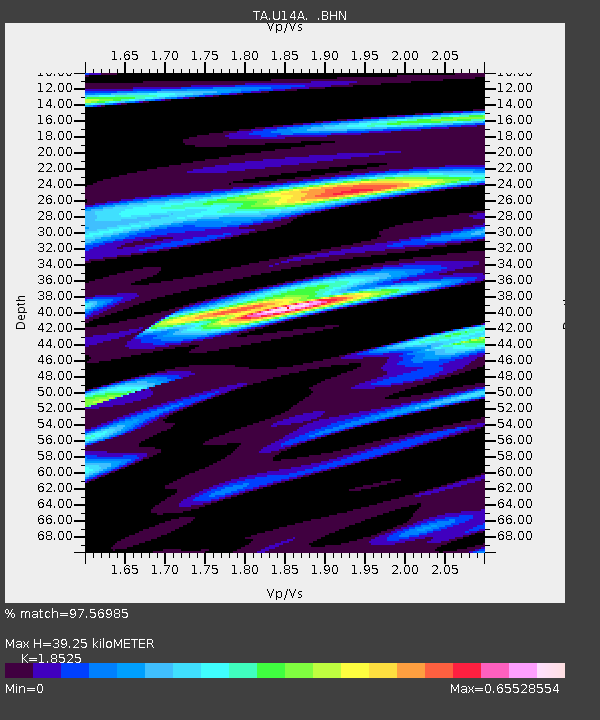
| Estimated Moho Depth: |
39.25 km |
| Estimated Crust Vp/Vs: |
1.85 |
| Assumed Crust Vp: |
6.194 km/s |
| Estimated Crust Vs: |
3.344 km/s |
| Estimated Crust Poisson's Ratio: |
0.29 |
|
| Radial Match: |
97.56985 % |
| Radial Bump: |
400 |
| Transverse Match: |
91.26771 % |
| Transverse Bump: |
400 |
| SOD ConfigId: |
2564 |
| Insert Time: |
2010-03-07 05:23:12.216 +0000 |
| GWidth: |
2.5 |
| Max Bumps: |
400 |
| Tol: |
0.001 |
|

Signal To Noise
| Channel | StoN | STA | LTA |
| TA:U14A: :BHN:20070401T20:52:46.348018Z | 1.4893986 | 2.5537145E-7 | 1.7145943E-7 |
| TA:U14A: :BHE:20070401T20:52:46.348018Z | 2.6564298 | 3.662694E-7 | 1.3788032E-7 |
| TA:U14A: :BHZ:20070401T20:52:46.348018Z | 4.632461 | 7.362595E-7 | 1.5893485E-7 |
| Arrivals |
| Ps | 5.5 SECOND |
| PpPs | 18 SECOND |
| PsPs/PpSs | 23 SECOND |


