You are here: Home > Network List > TA - USArray Transportable Network (new EarthScope stations) Stations List
> Station B22K Teshekpuk Lake, AK, USA > Earthquake Result Viewer
B22K Teshekpuk Lake, AK, USA - Earthquake Result Viewer

| Earthquake location: |
Mindanao, Philippines |
| Earthquake latitude/longitude: |
7.1/125.3 |
| Earthquake time(UTC): |
2019/10/31 (304) 01:11:20 GMT |
| Earthquake Depth: |
22 km |
| Earthquake Magnitude: |
6.8 Mi |
| Earthquake Catalog/Contributor: |
NEIC PDE/at |
|
| Network: |
TA USArray Transportable Network (new EarthScope stations) |
| Station: |
B22K Teshekpuk Lake, AK, USA |
| Lat/Lon: |
70.34 N/153.42 W |
| Elevation: |
50 m |
|
| Distance: |
80.4 deg |
| Az: |
19.832 deg |
| Baz: |
264.178 deg |
| Ray Param: |
0.048267994 |
| Estimated Moho Depth: |
12.0 km |
| Estimated Crust Vp/Vs: |
1.60 |
| Assumed Crust Vp: |
5.738 km/s |
| Estimated Crust Vs: |
3.586 km/s |
| Estimated Crust Poisson's Ratio: |
0.18 |
|
| Radial Match: |
80.57038 % |
| Radial Bump: |
400 |
| Transverse Match: |
76.30557 % |
| Transverse Bump: |
352 |
| SOD ConfigId: |
19951751 |
| Insert Time: |
2019-11-14 01:21:38.565 +0000 |
| GWidth: |
2.5 |
| Max Bumps: |
400 |
| Tol: |
0.001 |
|
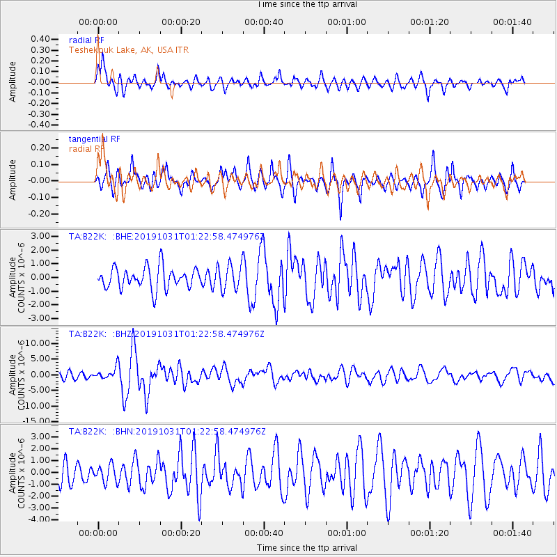
Signal To Noise
| Channel | StoN | STA | LTA |
| TA:B22K: :BHZ:20191031T01:22:58.474976Z | 1.9922869 | 2.011405E-6 | 1.0095962E-6 |
| TA:B22K: :BHN:20191031T01:22:58.474976Z | 0.97986 | 7.524986E-7 | 7.6796545E-7 |
| TA:B22K: :BHE:20191031T01:22:58.474976Z | 1.2019285 | 9.289542E-7 | 7.728864E-7 |
| Arrivals |
| Ps | 1.3 SECOND |
| PpPs | 5.3 SECOND |
| PsPs/PpSs | 6.6 SECOND |


