You are here: Home > Network List > TA - USArray Transportable Network (new EarthScope stations) Stations List
> Station C18K Utukok River, AK, USA > Earthquake Result Viewer
C18K Utukok River, AK, USA - Earthquake Result Viewer
| Earthquake location: |
Mindanao, Philippines |
| Earthquake latitude/longitude: |
7.1/125.3 |
| Earthquake time(UTC): |
2019/10/31 (304) 01:11:20 GMT |
| Earthquake Depth: |
22 km |
| Earthquake Magnitude: |
6.8 Mi |
| Earthquake Catalog/Contributor: |
NEIC PDE/at |
|
| Network: |
TA USArray Transportable Network (new EarthScope stations) |
| Station: |
C18K Utukok River, AK, USA |
| Lat/Lon: |
68.65 N/161.19 W |
| Elevation: |
845 m |
|
| Distance: |
77.4 deg |
| Az: |
21.085 deg |
| Baz: |
257.141 deg |
| Ray Param: |
0.05029764 |
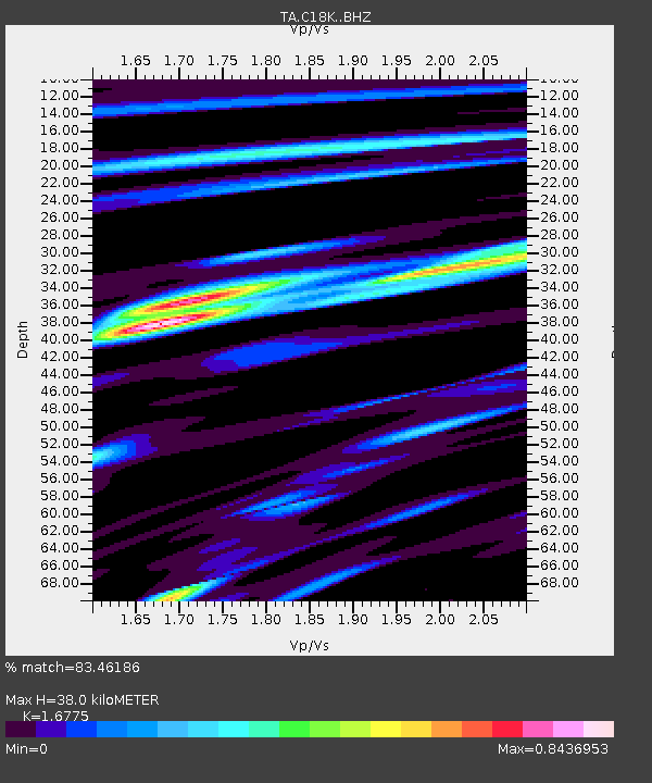
| Estimated Moho Depth: |
38.0 km |
| Estimated Crust Vp/Vs: |
1.68 |
| Assumed Crust Vp: |
5.906 km/s |
| Estimated Crust Vs: |
3.521 km/s |
| Estimated Crust Poisson's Ratio: |
0.22 |
|
| Radial Match: |
83.46186 % |
| Radial Bump: |
400 |
| Transverse Match: |
78.4345 % |
| Transverse Bump: |
391 |
| SOD ConfigId: |
19951751 |
| Insert Time: |
2019-11-14 01:21:39.639 +0000 |
| GWidth: |
2.5 |
| Max Bumps: |
400 |
| Tol: |
0.001 |
|

Signal To Noise
| Channel | StoN | STA | LTA |
| TA:C18K: :BHZ:20191031T01:22:42.200012Z | 2.461228 | 1.3404318E-6 | 5.446191E-7 |
| TA:C18K: :BHN:20191031T01:22:42.200012Z | 0.478845 | 3.461822E-7 | 7.229525E-7 |
| TA:C18K: :BHE:20191031T01:22:42.200012Z | 1.1299186 | 5.689189E-7 | 5.035044E-7 |
| Arrivals |
| Ps | 4.5 SECOND |
| PpPs | 17 SECOND |
| PsPs/PpSs | 21 SECOND |


