You are here: Home > Network List > TA - USArray Transportable Network (new EarthScope stations) Stations List
> Station D17K Noatak River, AK, USA > Earthquake Result Viewer
D17K Noatak River, AK, USA - Earthquake Result Viewer
| Earthquake location: |
Mindanao, Philippines |
| Earthquake latitude/longitude: |
7.1/125.3 |
| Earthquake time(UTC): |
2019/10/31 (304) 01:11:20 GMT |
| Earthquake Depth: |
22 km |
| Earthquake Magnitude: |
6.8 Mi |
| Earthquake Catalog/Contributor: |
NEIC PDE/at |
|
| Network: |
TA USArray Transportable Network (new EarthScope stations) |
| Station: |
D17K Noatak River, AK, USA |
| Lat/Lon: |
67.70 N/163.08 W |
| Elevation: |
172 m |
|
| Distance: |
76.5 deg |
| Az: |
21.866 deg |
| Baz: |
255.565 deg |
| Ray Param: |
0.050909784 |
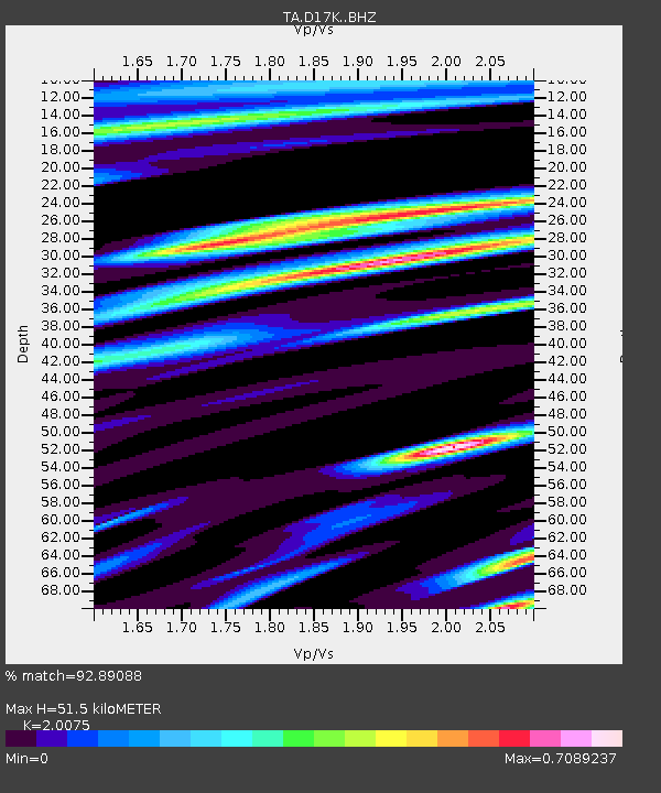
| Estimated Moho Depth: |
51.5 km |
| Estimated Crust Vp/Vs: |
2.01 |
| Assumed Crust Vp: |
6.276 km/s |
| Estimated Crust Vs: |
3.126 km/s |
| Estimated Crust Poisson's Ratio: |
0.33 |
|
| Radial Match: |
92.89088 % |
| Radial Bump: |
400 |
| Transverse Match: |
86.64433 % |
| Transverse Bump: |
400 |
| SOD ConfigId: |
19951751 |
| Insert Time: |
2019-11-14 01:21:42.464 +0000 |
| GWidth: |
2.5 |
| Max Bumps: |
400 |
| Tol: |
0.001 |
|

Signal To Noise
| Channel | StoN | STA | LTA |
| TA:D17K: :BHZ:20191031T01:22:37.099976Z | 2.995261 | 7.7670194E-7 | 2.5931027E-7 |
| TA:D17K: :BHN:20191031T01:22:37.099976Z | 1.7138387 | 5.694091E-7 | 3.3224197E-7 |
| TA:D17K: :BHE:20191031T01:22:37.099976Z | 1.0514727 | 3.1535745E-7 | 2.9991978E-7 |
| Arrivals |
| Ps | 8.5 SECOND |
| PpPs | 24 SECOND |
| PsPs/PpSs | 33 SECOND |


