You are here: Home > Network List > TA - USArray Transportable Network (new EarthScope stations) Stations List
> Station U14A Mt Trumbull, AZ, USA > Earthquake Result Viewer
U14A Mt Trumbull, AZ, USA - Earthquake Result Viewer

| Earthquake location: |
South Of Panama |
| Earthquake latitude/longitude: |
5.0/-82.7 |
| Earthquake time(UTC): |
2008/06/17 (169) 17:42:09 GMT |
| Earthquake Depth: |
10 km |
| Earthquake Magnitude: |
5.6 MB, 5.3 MS, 5.9 MW, 5.9 MW |
| Earthquake Catalog/Contributor: |
WHDF/NEIC |
|
| Network: |
TA USArray Transportable Network (new EarthScope stations) |
| Station: |
U14A Mt Trumbull, AZ, USA |
| Lat/Lon: |
36.42 N/113.18 W |
| Elevation: |
1916 m |
|
| Distance: |
42.0 deg |
| Az: |
322.221 deg |
| Baz: |
130.831 deg |
| Ray Param: |
0.07344999 |
| Estimated Moho Depth: |
43.0 km |
| Estimated Crust Vp/Vs: |
1.71 |
| Assumed Crust Vp: |
6.194 km/s |
| Estimated Crust Vs: |
3.633 km/s |
| Estimated Crust Poisson's Ratio: |
0.24 |
|
| Radial Match: |
84.32078 % |
| Radial Bump: |
400 |
| Transverse Match: |
54.997963 % |
| Transverse Bump: |
400 |
| SOD ConfigId: |
2504 |
| Insert Time: |
2010-03-07 05:23:20.376 +0000 |
| GWidth: |
2.5 |
| Max Bumps: |
400 |
| Tol: |
0.001 |
|
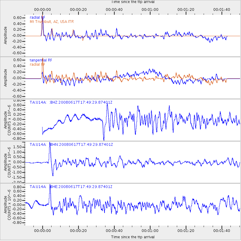
Signal To Noise
| Channel | StoN | STA | LTA |
| TA:U14A: :BHN:20080617T17:49:29.87401Z | 7.0919046 | 6.418601E-7 | 9.050603E-8 |
| TA:U14A: :BHE:20080617T17:49:29.87401Z | 2.0936272 | 3.6449825E-7 | 1.7409893E-7 |
| TA:U14A: :BHZ:20080617T17:49:29.87401Z | 1.1459112 | 2.6373183E-7 | 2.301503E-7 |
| Arrivals |
| Ps | 5.2 SECOND |
| PpPs | 18 SECOND |
| PsPs/PpSs | 23 SECOND |


