You are here: Home > Network List > TA - USArray Transportable Network (new EarthScope stations) Stations List
> Station F26K Sheenjek River, AK, USA > Earthquake Result Viewer
F26K Sheenjek River, AK, USA - Earthquake Result Viewer
| Earthquake location: |
Mindanao, Philippines |
| Earthquake latitude/longitude: |
7.1/125.3 |
| Earthquake time(UTC): |
2019/10/31 (304) 01:11:20 GMT |
| Earthquake Depth: |
22 km |
| Earthquake Magnitude: |
6.8 Mi |
| Earthquake Catalog/Contributor: |
NEIC PDE/at |
|
| Network: |
TA USArray Transportable Network (new EarthScope stations) |
| Station: |
F26K Sheenjek River, AK, USA |
| Lat/Lon: |
67.69 N/144.15 W |
| Elevation: |
683 m |
|
| Distance: |
83.7 deg |
| Az: |
22.584 deg |
| Baz: |
273.215 deg |
| Ray Param: |
0.045983348 |
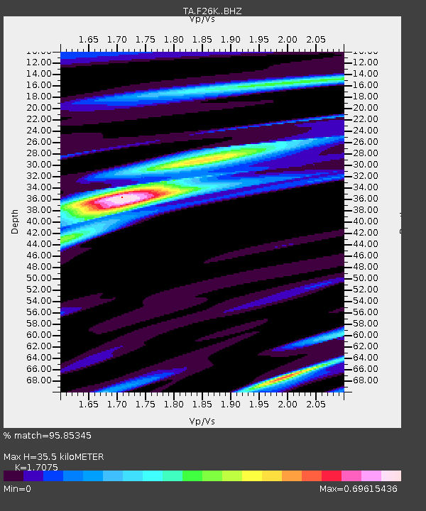
| Estimated Moho Depth: |
35.5 km |
| Estimated Crust Vp/Vs: |
1.71 |
| Assumed Crust Vp: |
6.522 km/s |
| Estimated Crust Vs: |
3.819 km/s |
| Estimated Crust Poisson's Ratio: |
0.24 |
|
| Radial Match: |
95.85345 % |
| Radial Bump: |
400 |
| Transverse Match: |
89.69049 % |
| Transverse Bump: |
400 |
| SOD ConfigId: |
19951751 |
| Insert Time: |
2019-11-14 01:22:00.487 +0000 |
| GWidth: |
2.5 |
| Max Bumps: |
400 |
| Tol: |
0.001 |
|

Signal To Noise
| Channel | StoN | STA | LTA |
| TA:F26K: :BHZ:20191031T01:23:15.599976Z | 1.6891171 | 2.6677822E-7 | 1.5793945E-7 |
| TA:F26K: :BHN:20191031T01:23:15.599976Z | 1.227574 | 1.1154204E-7 | 9.086381E-8 |
| TA:F26K: :BHE:20191031T01:23:15.599976Z | 1.0441618 | 8.584803E-8 | 8.221718E-8 |
| Arrivals |
| Ps | 4.0 SECOND |
| PpPs | 14 SECOND |
| PsPs/PpSs | 18 SECOND |


