You are here: Home > Network List > TA - USArray Transportable Network (new EarthScope stations) Stations List
> Station H27K Steamboat Mountain, AK, USA > Earthquake Result Viewer
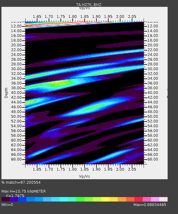
H27K Steamboat Mountain, AK, USA - Earthquake Result Viewer
| Earthquake location: |
Mindanao, Philippines |
| Earthquake latitude/longitude: |
7.1/125.3 |
| Earthquake time(UTC): |
2019/10/31 (304) 01:11:20 GMT |
| Earthquake Depth: |
22 km |
| Earthquake Magnitude: |
6.8 Mi |
| Earthquake Catalog/Contributor: |
NEIC PDE/at |
|
| Network: |
TA USArray Transportable Network (new EarthScope stations) |
| Station: |
H27K Steamboat Mountain, AK, USA |
| Lat/Lon: |
66.23 N/141.53 W |
| Elevation: |
786 m |
|
| Distance: |
84.8 deg |
| Az: |
23.976 deg |
| Baz: |
275.762 deg |
| Ray Param: |
0.04517423 |
| Estimated Moho Depth: |
10.75 km |
| Estimated Crust Vp/Vs: |
1.77 |
| Assumed Crust Vp: |
6.577 km/s |
| Estimated Crust Vs: |
3.721 km/s |
| Estimated Crust Poisson's Ratio: |
0.26 |
|
| Radial Match: |
97.200554 % |
| Radial Bump: |
383 |
| Transverse Match: |
90.228325 % |
| Transverse Bump: |
400 |
| SOD ConfigId: |
19951751 |
| Insert Time: |
2019-11-14 01:22:12.720 +0000 |
| GWidth: |
2.5 |
| Max Bumps: |
400 |
| Tol: |
0.001 |
|

Signal To Noise
| Channel | StoN | STA | LTA |
| TA:H27K: :BHZ:20191031T01:23:21.375Z | 3.6335993 | 2.801217E-7 | 7.709207E-8 |
| TA:H27K: :BHN:20191031T01:23:21.375Z | 1.2803028 | 1.4316717E-7 | 1.118229E-7 |
| TA:H27K: :BHE:20191031T01:23:21.375Z | 2.5716252 | 2.8647992E-7 | 1.1140033E-7 |
| Arrivals |
| Ps | 1.3 SECOND |
| PpPs | 4.4 SECOND |
| PsPs/PpSs | 5.7 SECOND |


