You are here: Home > Network List > IU - Global Seismograph Network (GSN - IRIS/USGS) Stations List
> Station PMG Port Moresby, New Guinea > Earthquake Result Viewer
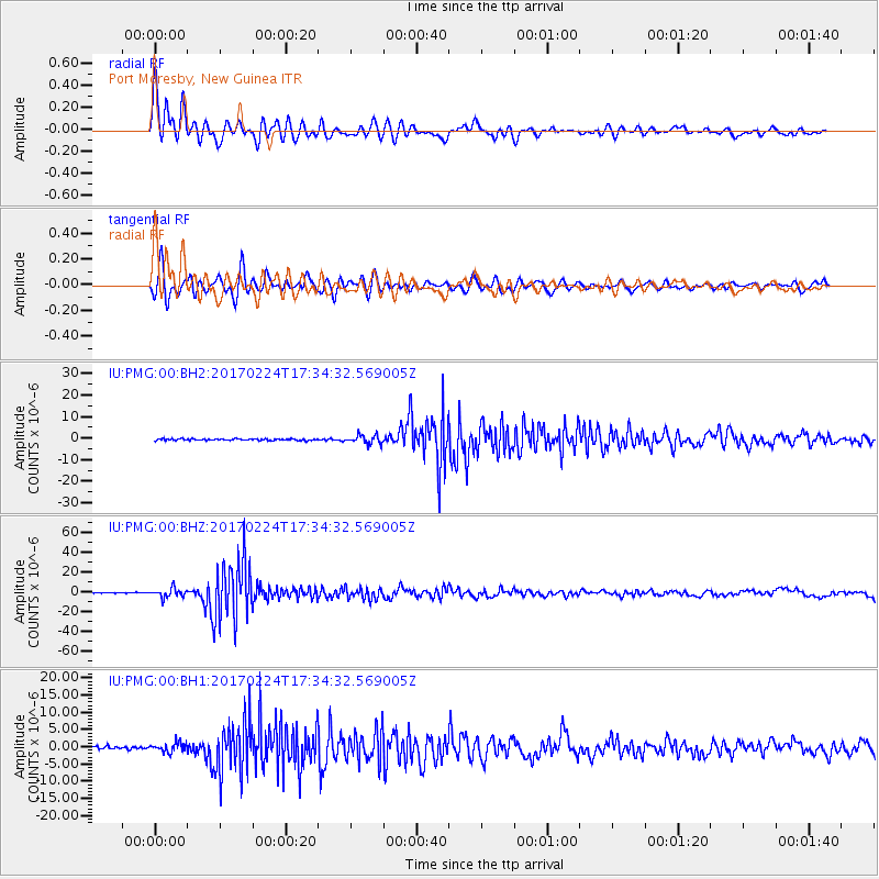
PMG Port Moresby, New Guinea - Earthquake Result Viewer
*The percent match for this event was below the threshold and hence no stack was calculated.
| Earthquake location: |
South Of Fiji Islands |
| Earthquake latitude/longitude: |
-23.2/-178.8 |
| Earthquake time(UTC): |
2017/02/24 (055) 17:28:44 GMT |
| Earthquake Depth: |
415 km |
| Earthquake Magnitude: |
6.9 mww |
| Earthquake Catalog/Contributor: |
NEIC PDE/us |
|
| Network: |
IU Global Seismograph Network (GSN - IRIS/USGS) |
| Station: |
PMG Port Moresby, New Guinea |
| Lat/Lon: |
9.40 S/147.16 E |
| Elevation: |
90 m |
|
| Distance: |
35.3 deg |
| Az: |
287.281 deg |
| Baz: |
117.118 deg |
| Ray Param: |
$rayparam |
*The percent match for this event was below the threshold and hence was not used in the summary stack. |
|
| Radial Match: |
92.95396 % |
| Radial Bump: |
400 |
| Transverse Match: |
88.30228 % |
| Transverse Bump: |
400 |
| SOD ConfigId: |
1992691 |
| Insert Time: |
2017-03-10 17:30:49.279 +0000 |
| GWidth: |
2.5 |
| Max Bumps: |
400 |
| Tol: |
0.001 |
|
Signal To Noise
| Channel | StoN | STA | LTA |
| IU:PMG:00:BHZ:20170224T17:34:32.569005Z | 11.677573 | 4.5098964E-6 | 3.862015E-7 |
| IU:PMG:00:BH1:20170224T17:34:32.569005Z | 3.2059107 | 1.3869623E-6 | 4.326266E-7 |
| IU:PMG:00:BH2:20170224T17:34:32.569005Z | 5.181736 | 2.0300588E-6 | 3.9177195E-7 |
| Arrivals |
| Ps | |
| PpPs | |
| PsPs/PpSs | |


