You are here: Home > Network List > TA - USArray Transportable Network (new EarthScope stations) Stations List
> Station M18K Stony River, AK, USA > Earthquake Result Viewer
M18K Stony River, AK, USA - Earthquake Result Viewer
| Earthquake location: |
Mindanao, Philippines |
| Earthquake latitude/longitude: |
7.1/125.3 |
| Earthquake time(UTC): |
2019/10/31 (304) 01:11:20 GMT |
| Earthquake Depth: |
22 km |
| Earthquake Magnitude: |
6.8 Mi |
| Earthquake Catalog/Contributor: |
NEIC PDE/at |
|
| Network: |
TA USArray Transportable Network (new EarthScope stations) |
| Station: |
M18K Stony River, AK, USA |
| Lat/Lon: |
61.49 N/155.82 W |
| Elevation: |
289 m |
|
| Distance: |
78.5 deg |
| Az: |
28.714 deg |
| Baz: |
263.608 deg |
| Ray Param: |
0.049585763 |
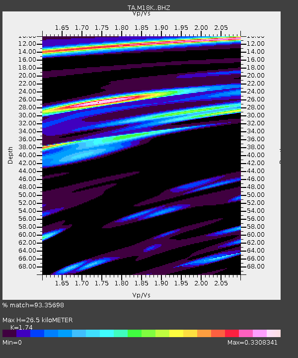
| Estimated Moho Depth: |
26.5 km |
| Estimated Crust Vp/Vs: |
1.74 |
| Assumed Crust Vp: |
6.566 km/s |
| Estimated Crust Vs: |
3.774 km/s |
| Estimated Crust Poisson's Ratio: |
0.25 |
|
| Radial Match: |
93.35698 % |
| Radial Bump: |
372 |
| Transverse Match: |
83.65096 % |
| Transverse Bump: |
390 |
| SOD ConfigId: |
19951751 |
| Insert Time: |
2019-11-14 01:22:28.785 +0000 |
| GWidth: |
2.5 |
| Max Bumps: |
400 |
| Tol: |
0.001 |
|

Signal To Noise
| Channel | StoN | STA | LTA |
| TA:M18K: :BHZ:20191031T01:22:48.000Z | 3.6367142 | 5.74222E-7 | 1.5789583E-7 |
| TA:M18K: :BHN:20191031T01:22:48.000Z | 1.0113156 | 1.5037335E-7 | 1.4869082E-7 |
| TA:M18K: :BHE:20191031T01:22:48.000Z | 1.615514 | 2.607202E-7 | 1.6138529E-7 |
| Arrivals |
| Ps | 3.1 SECOND |
| PpPs | 11 SECOND |
| PsPs/PpSs | 14 SECOND |


