You are here: Home > Network List > TA - USArray Transportable Network (new EarthScope stations) Stations List
> Station O17K Koliganek, Bristol Bay, AK, USA > Earthquake Result Viewer
O17K Koliganek, Bristol Bay, AK, USA - Earthquake Result Viewer
| Earthquake location: |
Mindanao, Philippines |
| Earthquake latitude/longitude: |
7.1/125.3 |
| Earthquake time(UTC): |
2019/10/31 (304) 01:11:20 GMT |
| Earthquake Depth: |
22 km |
| Earthquake Magnitude: |
6.8 Mi |
| Earthquake Catalog/Contributor: |
NEIC PDE/at |
|
| Network: |
TA USArray Transportable Network (new EarthScope stations) |
| Station: |
O17K Koliganek, Bristol Bay, AK, USA |
| Lat/Lon: |
59.77 N/157.09 W |
| Elevation: |
156 m |
|
| Distance: |
77.7 deg |
| Az: |
30.387 deg |
| Baz: |
262.848 deg |
| Ray Param: |
0.05014751 |
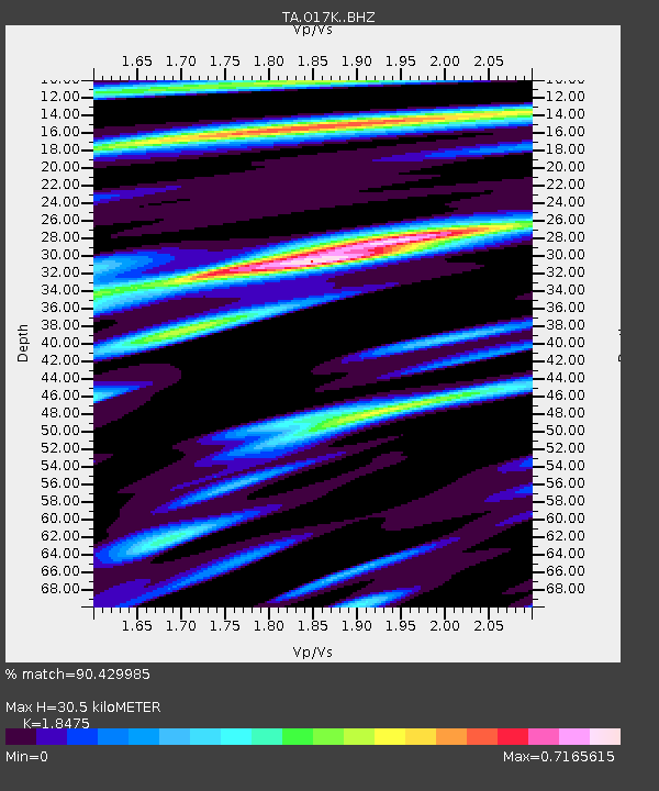
| Estimated Moho Depth: |
30.5 km |
| Estimated Crust Vp/Vs: |
1.85 |
| Assumed Crust Vp: |
6.276 km/s |
| Estimated Crust Vs: |
3.397 km/s |
| Estimated Crust Poisson's Ratio: |
0.29 |
|
| Radial Match: |
90.429985 % |
| Radial Bump: |
400 |
| Transverse Match: |
87.77387 % |
| Transverse Bump: |
400 |
| SOD ConfigId: |
19951751 |
| Insert Time: |
2019-11-14 01:22:38.382 +0000 |
| GWidth: |
2.5 |
| Max Bumps: |
400 |
| Tol: |
0.001 |
|
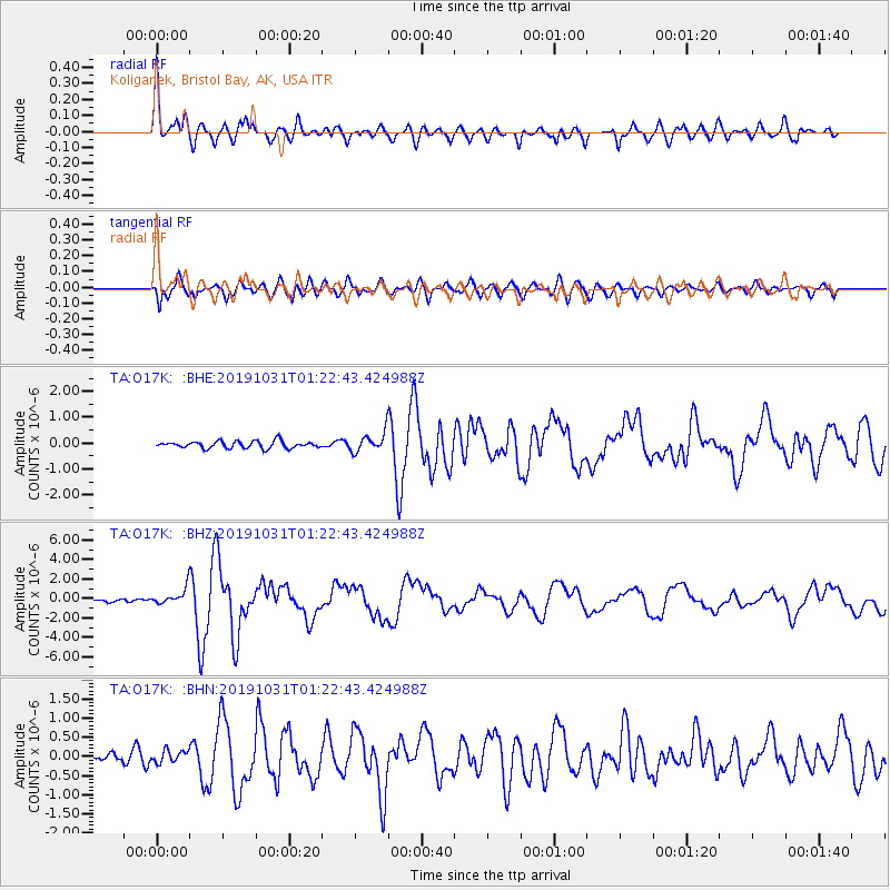
Signal To Noise
| Channel | StoN | STA | LTA |
| TA:O17K: :BHZ:20191031T01:22:43.424988Z | 4.2795606 | 8.3856145E-7 | 1.9594569E-7 |
| TA:O17K: :BHN:20191031T01:22:43.424988Z | 1.1596324 | 1.6016185E-7 | 1.3811433E-7 |
| TA:O17K: :BHE:20191031T01:22:43.424988Z | 2.7138433 | 3.71665E-7 | 1.3695154E-7 |
| Arrivals |
| Ps | 4.2 SECOND |
| PpPs | 13 SECOND |
| PsPs/PpSs | 18 SECOND |


